October 5, 2020
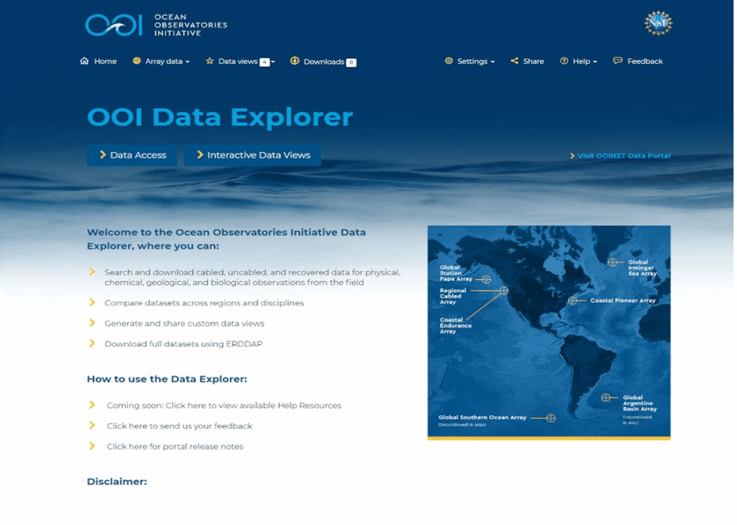
Accessing, visualizing, and integrating data from the NSF Ocean Observatories Initiative (OOI) into research and classrooms is a whole lot easier. The Ocean Observatories Initiative launched its new data exploration tool – OOI Data Explorer version 1.0 on 5 October https://dataexplorer.oceanobservatories.org . Data Explorer allows users to search and download cabled, uncabled, and recovered data, compare datasets across regions and disciplines, generate and share custom data views, and download full data sets using ERDDAP.
The OOI Data Team worked with Axiom Data Science to develop a data exploration system that is both powerful and user friendly. Version 1.0 has already been beta tested over the past three months by a subset of OOI scientific data users. This group’s feedback has improved Data Explorer, making it ready for broader distribution and use.
A live demonstration of Data Explorer is scheduled for 21 October at 2 pm EDT. This timeframe will allow users to try their hands using Data Explorer and come to the demonstration ready with specific questions about accessing data or suggestions on functions that could further enhance the user experience. To reserve a spot at the live demo, please register here .
“Data Explorer version 1.0 is the culmination of a process of listening to OOI data users and responding by implementing easier, more efficient, and useful means to deliver OOI data to them,” explained Jeffrey Glatstein, head of OOI’s Cyberinfrastructure, who guided a team of data and visualization experts in developing the tool. “It is an excellent tool that has been refined over the test period, and which we will continue to refine it in response to users’ suggestions. While continued improvements will be made and more data continually added, Data Explorer version 1.0 offers a great new way to find, access, and use OOI data.”
To ensure that all OOI data users maintain access to data, OOI’s current data portal will remain accessible and functional until the foreseeable future. Once all data have been exported to Data Explorer, tested, and vetted, only then will a complete switch be made to this new innovative tool.
The developers caution that Data Explorer version 1.0 may still have a few bugs, and users are asked to report them so the tool can be improved.
Added Glatstein, “Data Explorer is really a community-driven tool and it will be exciting to see how we can refine and improve it to meet the needs of our community.”
April 30, 2020
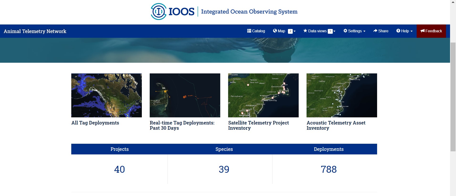
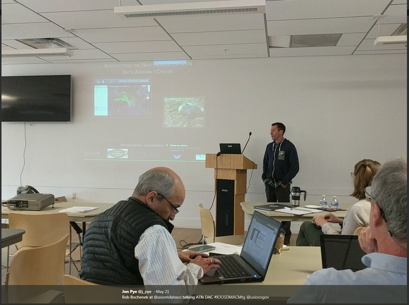
One of our projects at Axiom is the Animal Telemetry Network Data Assembly Center. As a librarian, one of the most exciting pieces of that project, to me, is the data portal. This portal, available at https://portal.atn.ioos.us/, allows for searching, exploring and accessing the multitude of data available through the research efforts of the Animal Telemetry Network. Funded by the Integrated Ocean Observing System and Office of Naval Research, the Animal Telemetry Network is a joint effort to track animal movement and behavior. You can learn more about the U.S. Animal Telemetry Network from NOAA here. The data portal homepage also has some highlighted projects available for getting familiar with the tools available and some of the datasets accessible through the catalog.
The blue navigation bar at the top of the data portal is the easiest way to get started. The catalog and map interface both have search functions, and the most familiar search interface for users is likely the catalog interface. Here there is a search bar for entering a search term, which will then trigger a full text search of the projects, datasets, and platforms available. In our search example, “Sea lions”, 215 results were returned, and the icons to the left of each result title show if that catalog entry is a project (book), or sensor (rectangular tag), and so on. The small menu directly below the search box are filters available for you to sort your results based on these types of entries.
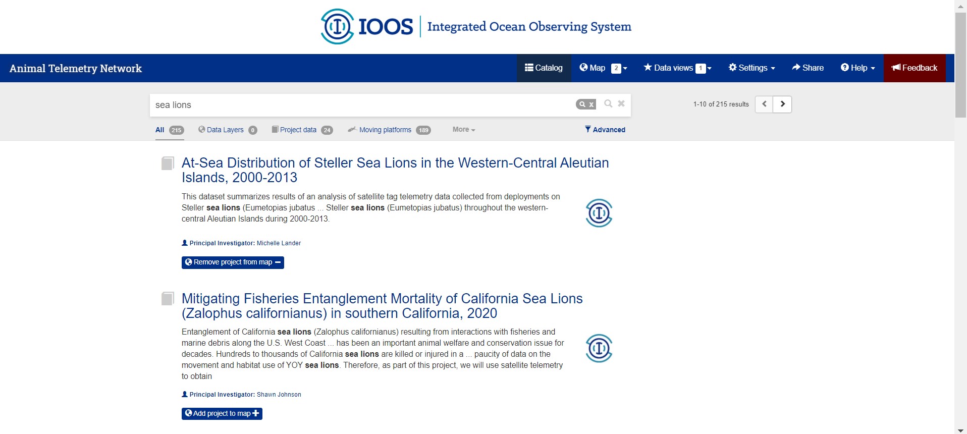
From the search results page, selecting the title of the entry will take the user to the catalog entry page. Here the full metadata details are available, as well as a preview box with a world map giving a high-level ‘quick view’ of the data. These metadata provide the user with more details about the project that gathered the data, such as the title, purpose, the primary investigators and other team members involved, and so on. There are also lists available, in this example, of the deployments, and the data files available for download for users interested in re-using this data. Three cheers for FAIR research!
Once you’ve searched out and landed on a dataset you’d like to explore visually, it’s easy to add that data to your map. Directly below the title on a catalog entry page is a blue button with an earth icon and a plus sign labeled, “Add project to map”. Click and the ‘counter’ icon next to the “Map” button at the top of the page will increase to show you at a glance how many layers you are working with. The “add” button on the catalog entry page will switch to “Remove project from map” if ever you need to do that, instead.
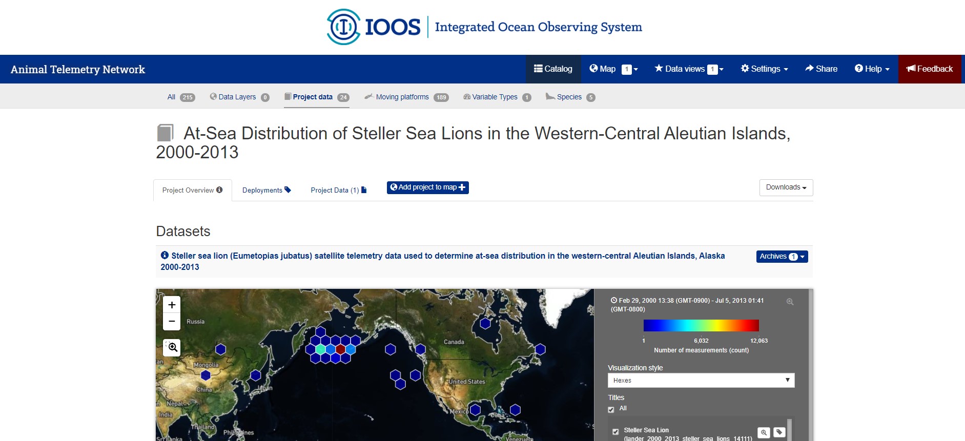
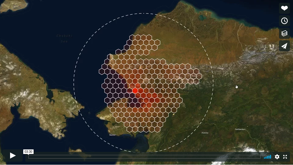
Clicking on the “Map” Button from the blue navigation bar at the top of the portal webpage will bring you to the world view map for visualizing and exploring. The Map shows a split view: it is a zoom-capable map viewer on the left, and a legend bar in a section on the right. The legend bar has a box for each ‘data layer’ you have added from the ATN data catalog. These legend boxes give you options to change the visualization style, select specific data points, and overview information such as the count of measurements in that dataset. There are multiple ways to scale or ‘zoom’ on the map. The first is clicking, scrolling and double clicking directly in the map. The second option is available right from the legend box, where a magnifying glass icon next to the data layer title will ‘zoom to extent’ of the datapoints in that specific layer. This is pictured below. The third option is with the tools available in the top left of the map, a plus sign to zoom in, a negative sign to zoom out, and a tool that will allow you to use your mouse to ‘click and drag’ a focus box to zoom on.
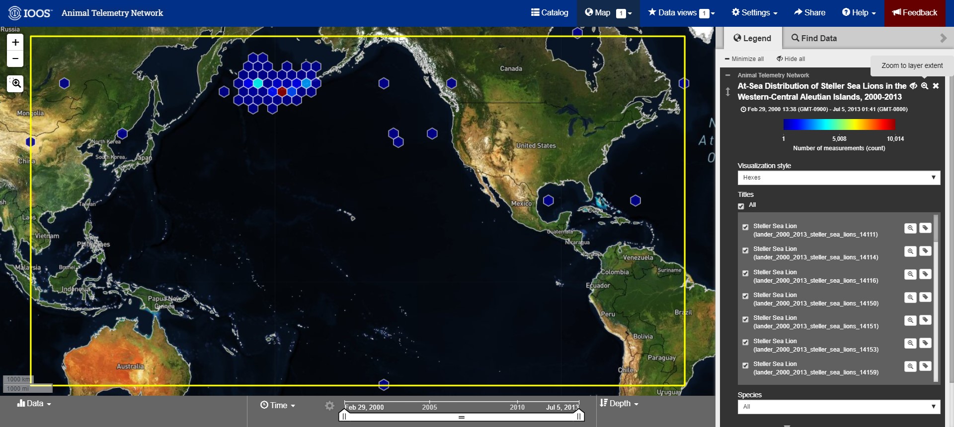
So, folks may be wondering what are these hexagon shapes, the visualization style called ‘hexes’. These hexbins are automatically adjusting to the particulars of your selected data. They give an indication of datapoints at their locations, and the density there. Zooming in and out automatically changes the calculations and the density of this view, which is why more or fewer hexbins appear at different scales of the map.
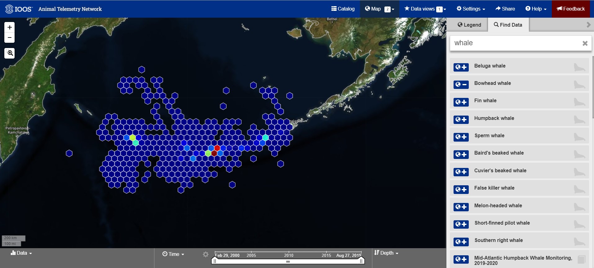
There is an option to add more data layers to the map directly from this interface as well. Next to the legend box title, there is a “Find Data” tab that provides a box for search terms, and lists results from the ATN data catalog by their titles. This is shown in the screenshot below. In this example, I added Bowhead whale data layer by clicking the blue icon ot the left of the result listing. The icon switched from a plus sign to a negative sign to show me that I was successfully, as well as the ‘counter’ next to my Maps button in the top navigation bar increasing.
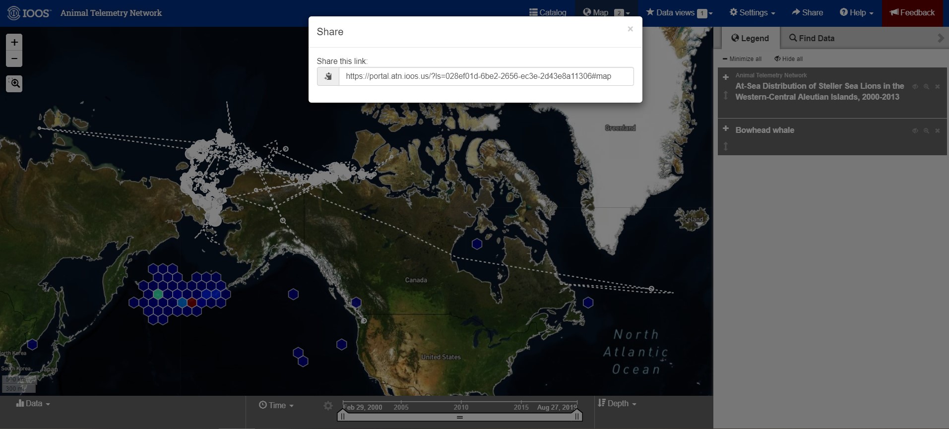
Once the map and the data layers are built to satisfaction, there is an option to ‘Share’ that really cool visual. In the top navigation bar, to the left of the help documentation, is a ‘Share’ button. This button will generate a URL that allows anyone to visit this specific map visualization, and then explore and add data with all the same tools. Share the science!
Researchers can contribute to ATN’s Data Catalog by submitting the data feeds from a tag vendor for your project. Visit this registration portal, for step by step instructions: https://atn.ioos.us/help/submit-data/ . This process will walk the user through the metadata requirements, klike TItle, Abstract, PIs and deployment information for the sensor. Then, you will need to contact your tag venor and authorize ATN DAC account to access the data feeds. The ATN Data coordinator will review your project and contact you with questions.
Thank you for your attention, please feel free to reach out to us with any questions or feedback by the Feedback form or email at info@axiomdatascience.com. If you’ve found this post thanks to EGU 2020, we hope you’re doing well and enjoying the virtual conference!
April 24, 2020
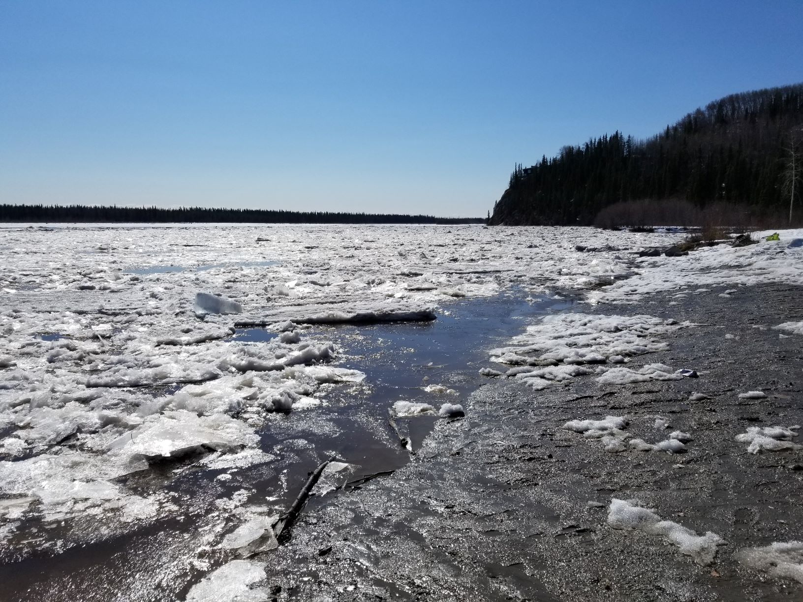
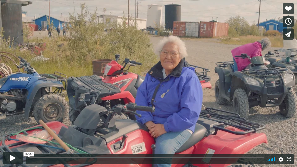
Axiom Data Science and UAF’s Fresh Eyes on Ice project have teamed up to provide a citizen science tool for sharing river ice observations. The National Weather Service River Forecast Desk, recognizing the value of these observations, are receiving these observations immediately so that their forecasting desk has best-available information during break up season.
Read more about Axiom Ice Observation tool or create your own observation. Approved observations will be added to a map layer in the Axiom-created Fresh Eyes on Ice data portal.
Axiom Data Science congratulates UAF’s Fresh Eyes on Ice program on providing up-to-the minute quality ice data observations to the public, and Fairbanks forecasters.
Photo credit: Chris Arp
December 2, 2019
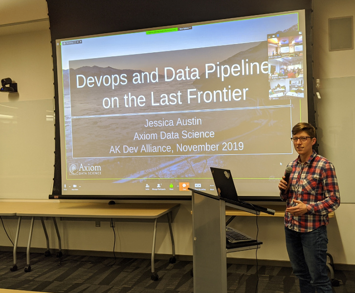
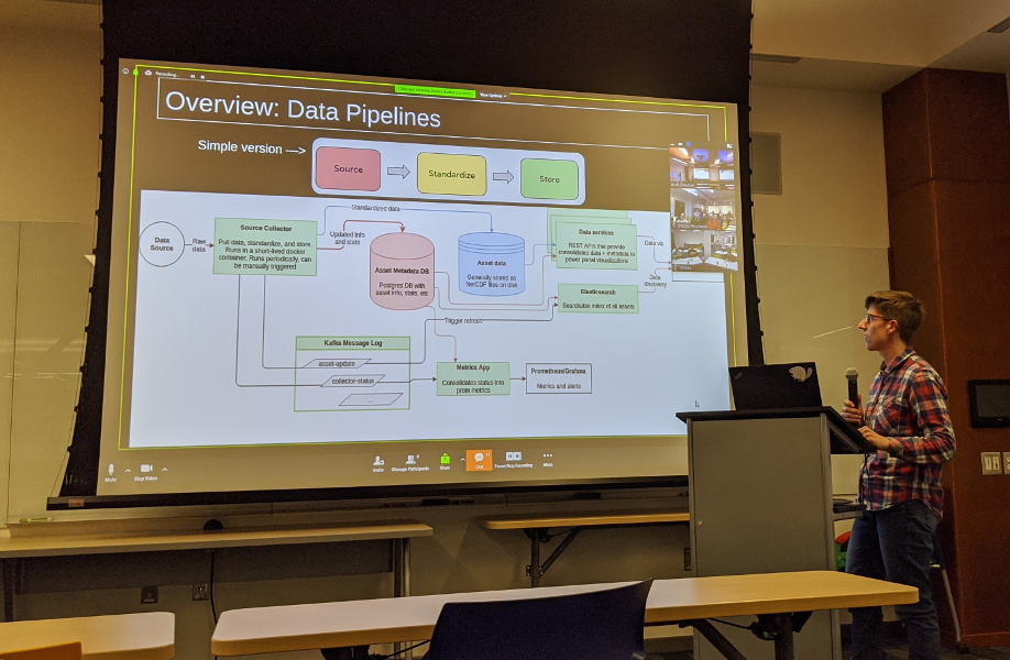
Fairbanks-based software developer Jessica Austin gave a talk recently at the Alaska Developer Alliance’s monthly meetup.
Slides from the talk are available as google slides or pdf and a video feed is available on youtube.
January 24, 2019
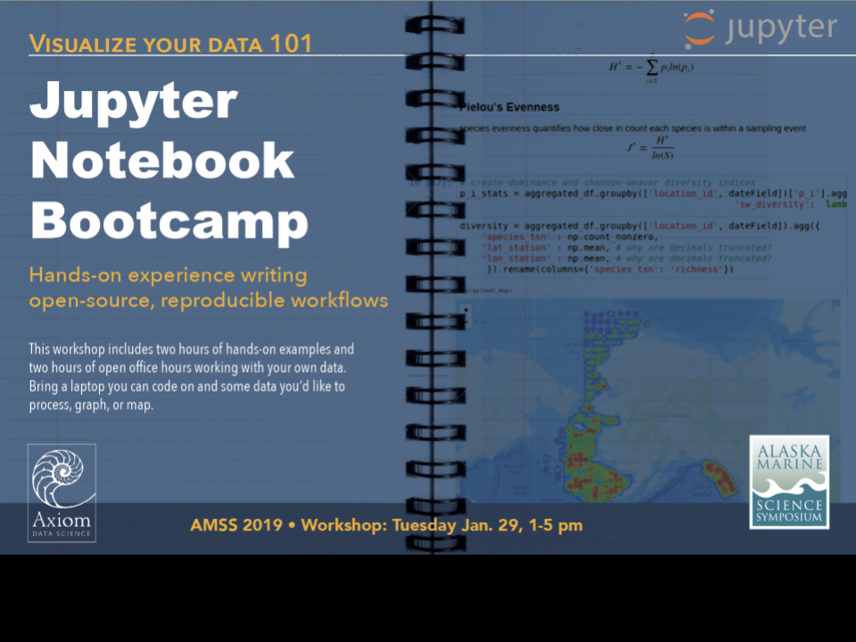
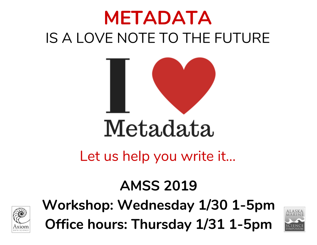
The Alaska Marine Science Symposium (AMSS) will be happening January 28- Feburary 1 in Anchorage. The AMSS is Alaska’s premier marine research conference, which has been bringing together scientists, educators, resource managers, students, and interested public for over twenty years to discuss the latest marine research being conducted in Alaskan waters.
Axiom will be hosting several workshops focused on Jupyter Notebooks and metadata creation using the Research Workspace. Additionally, we will be available to answer questions, provide assistance, and arm you with the tools to make you fall in love with data and metadata all over again. Come check us out!
Click for more information on the AMSS workshops or see the fliers below.
January 15, 2019
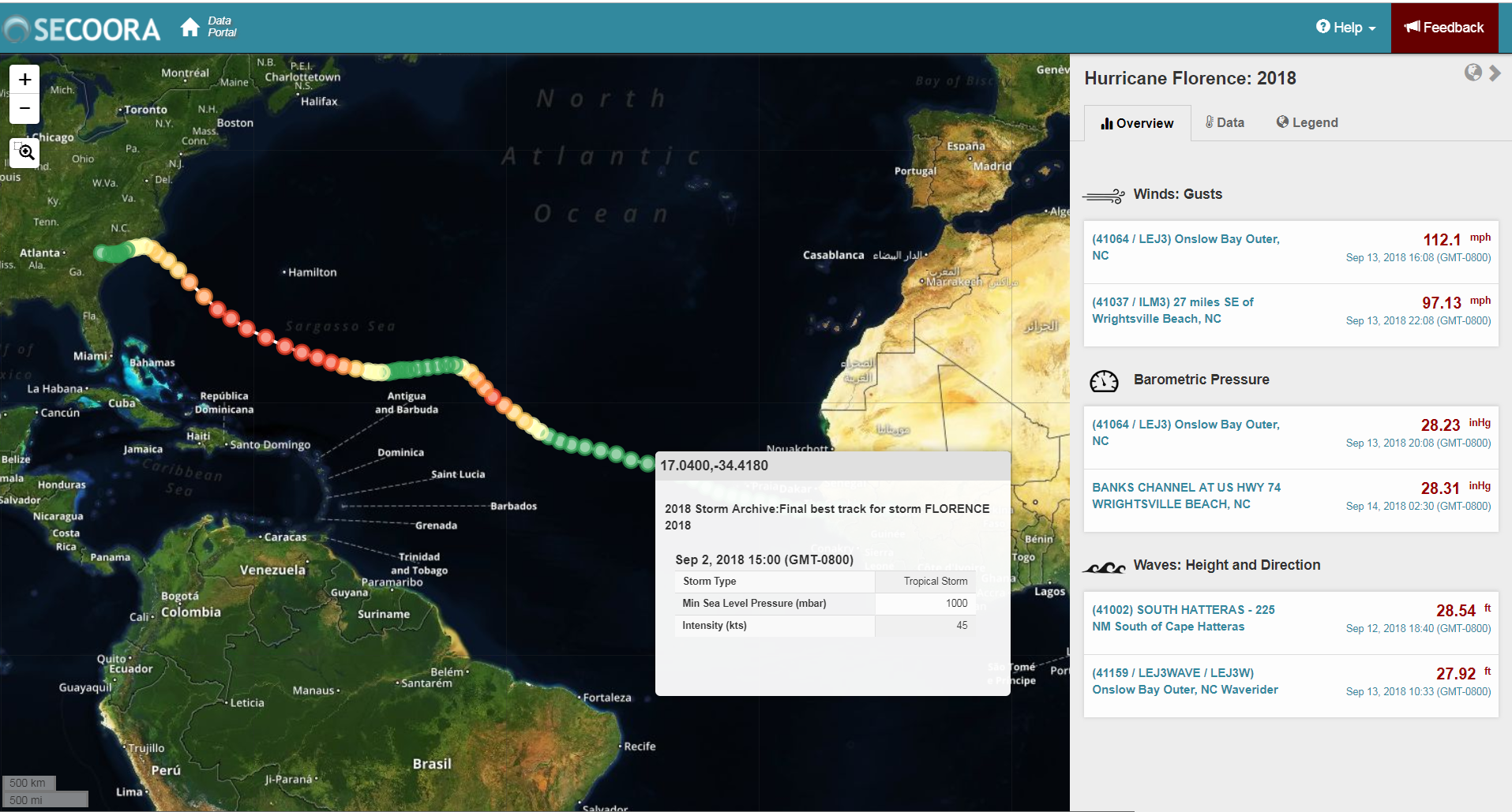
The Southeast Coastal Ocean Observing Regional Association (SECOORA), U.S. IOOS, and partners support marine weather buoys and coastal stations off of the Southeast coast. The information collected by these assets provides real-time information on approaching storms and hurricanes. Axiom Data Science, in partnership with SECOORA, have released a new Hurricane Data Tool to visualize hurricane tracks together with weather data from nearby observation stations and weather models. This tool allows users to quickly gain access to real-time or historical weather data from anywhere along the hurricane’s path.
Click to view the new Hurricane Data Tool or watch this short instructional tutorial. We are interested in hearing your ideas for expanding or improving this tool by using the Feedback tab or emailing: communications@secoora.org.
December 17, 2018
The Southeast Coastal Ocean Observing Regional Association (SECOORA) hosted a WebCAT workshop in November in Charleston, SC as part of the workshop titled Exploring Applications, Opportunities and Challenges to using Webcams for Environmental Monitoring.
The NOAA NOS Web Camera Applications Testbed (WebCAT) is a short-term project that is installing web cameras in five locations for various purposes – counting right whales, spotting rip currents, validating wave run up models, understanding human use of natural resources and more. This unique project is a public-private partnership leveraging the expertise and capabilities of private, nonprofit and public sectors. At this workshop, Axiom’s Dave Foster presented the role of the Axiom team in the overall project. Dave discussed how we retrieve the archival video footage from each station and make it available alongside live camera streams. Visit here for more information.
November 1, 2018
This year’s OCEANS Conference took place from October 22-25 in Charleston, South Carolina.
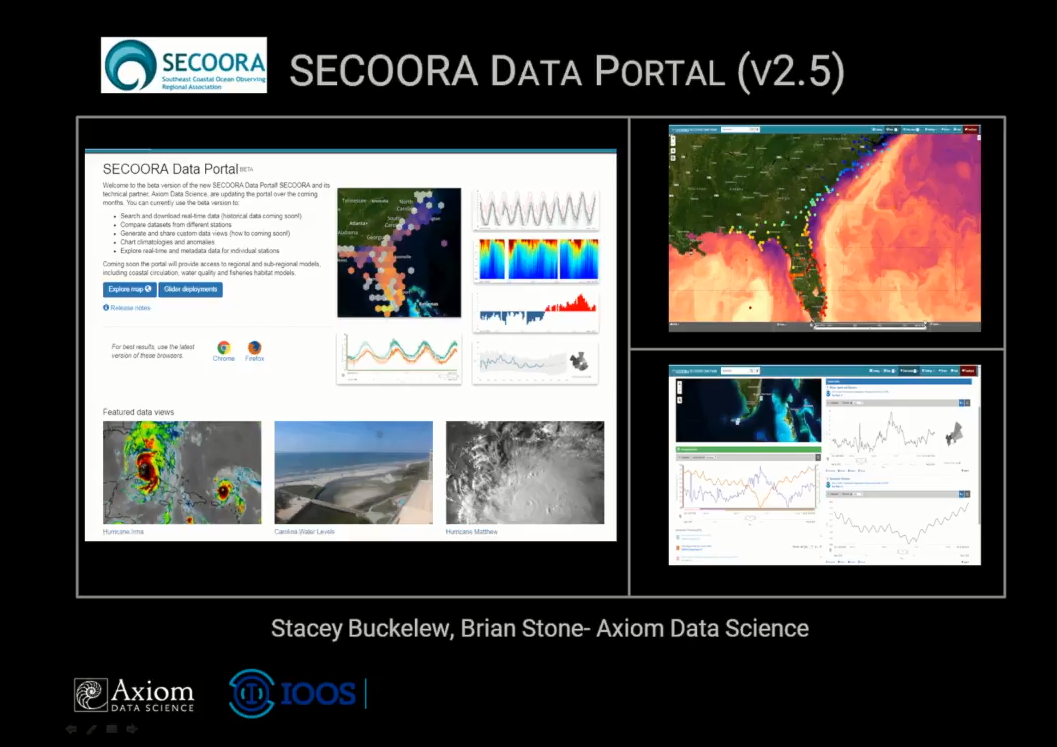
There were 31 participants representing federal, state, NGO, university and international organizations. Here Axiom’s Kyle Wilcox, Stacey Buckelew and Brian Stone attended the conference. Kyle Wilcox presented a
workshop on Data Access for the Southeast US Coasts and Oceans: An introduction and Demonstration of the SECOORA Data Portal and Service Offerings.
The Southeast Coastal Ocean Observing Regional Association (SECOORA) maintains an end-to-end data system that supports stakeholders in the ocean science community throughout the data lifecycle: from immediately after data collection, through analysis and synthesis, visualization, and decision making, to data publication and reuse. Without delving too deeply into technical details, the Axiom team discussed the design approach, system architecture, implementation, and use of the product. Axiom showed users how to discover, access, and analyze coastal data in the Southeast US through the SECOORA Data System for research, recreation, management, or curiosity. Visit here for more information about this conference.
August 30, 2018
We are pleased to announce Elizabeth (‘Liz’) Dobbins as the new Environmental Data Scientist for the Fairbanks, AK office. In this capacity, Liz will serve an important role providing managing and maintaining a vast network of in-situ oceanographic observation data for access and reuse in various web-based portals. Liz received a Masters degree in Physical Oceanography from the University of Washington, Seattle, WA. Since then, she’s supported interdisciplinary scientific endeavors in wildly disparate ways - from Unix system administration to fieldwork north of the Arctic Circle. In 2009, Liz relocated with her family to Fairbanks, AK, where she has focused on processing data collected in Alaskan waters and creating near real-time web maps. More recently, she’s become intrigued by the philosophy of Reproducible Research and the open-source software that supports it. In her spare time, Liz can be found on the roads of Fairbanks, shuttling kids between ski teams and ballet lessons. Welcome to the team, Liz! We are very happy to have you as part of our team.
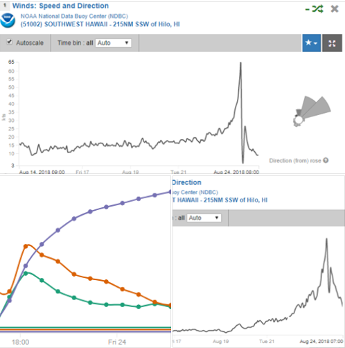
August 24, 2018
Need data for Hurricane Lane? There’s a new data dashboard on the Environmental Sensor Map–click through for data streamed from in and around Hawaii: Hurricane Lane tracking.
Or for the latest forecasts, watches and warnings follow the Central Pacific Hurricane Center.
Follow IOOS on Facebook and on Twitter.
August 15, 2018
Axiom Data Science seeks a Science Coordinator for the U.S. Animal Telemetry Network (ATN) Data Assembly Center (DAC). The U.S. ATN is supported by multiple Federal agencies and is hosted at the U.S. Integrated Ocean Observing System (U.S. IOOS) Program Office in partnership with the IOOC member agencies and in collaboration with the community of U.S. IOOS Regional Associations (RAs) and regional experts. Axiom develops and operates the enterprise-level cyberinfrastructure dedicated to the operational execution, support and customer service for the ATN DAC.
This position will be the primary interface between the U.S. marine animal telemetry community - satellite, acoustic and archival - and the software engineers and data scientists who operate the technical components of the ATN DAC. The position will actively solicit telemetry community researchers to become data contributing members of the ATN and will work closely with all regional and national ATN collaborators to train and assist them with data and metadata submission to the DAC in accordance with ATN data policies.
This position will be based out of the central coastal California area, working initially at Axiom's partner office in Moss Landing with the Central and Northern California Ocean Observing System (CeNCOOS) collocated at the Monterey Bay Aquarium Research Institute (MBARI).
Send questions or applications to careers@axds.co by September 21, 2018.

July 1, 2018
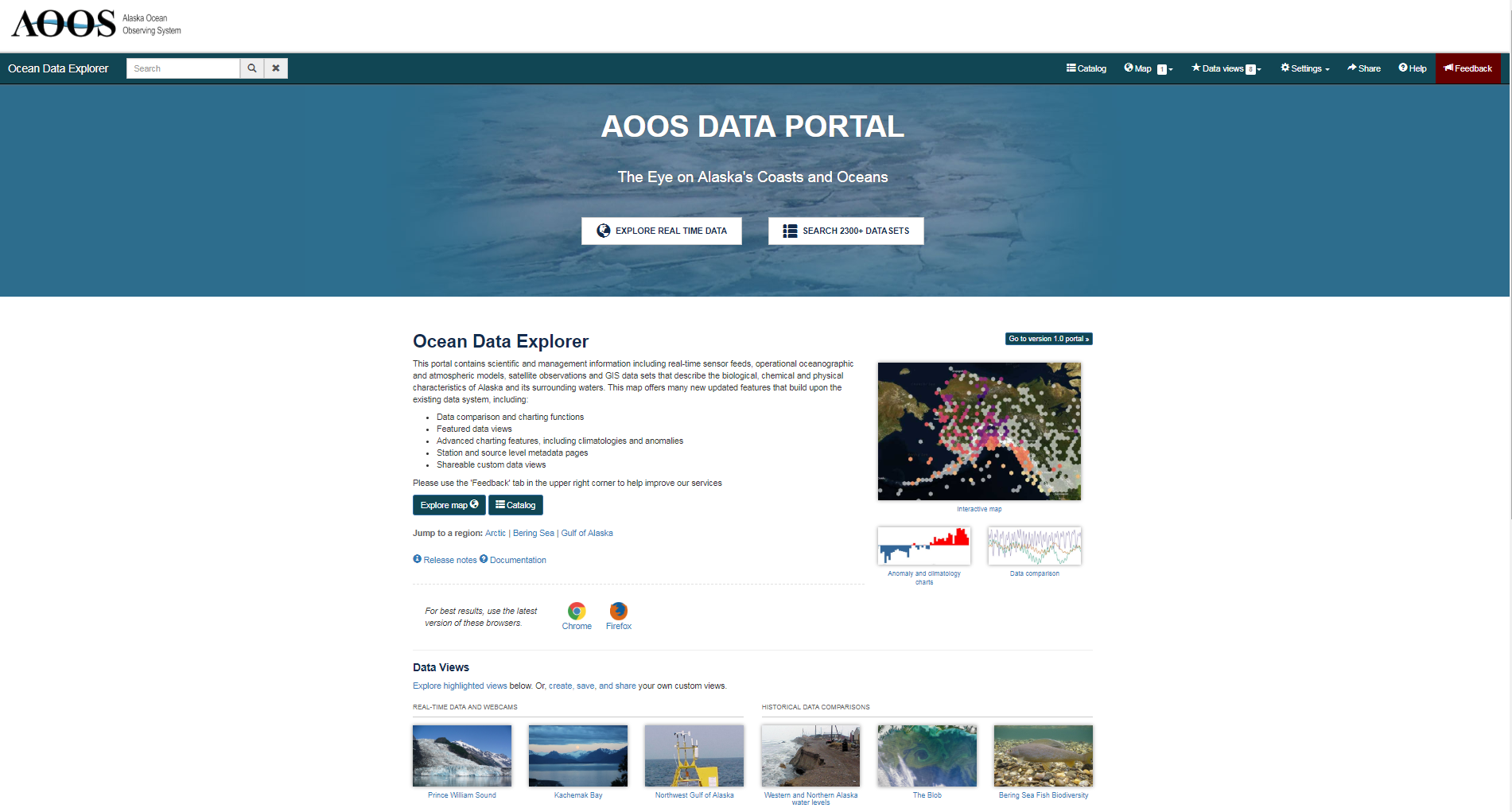
Building on many years of stakeholder feedback, Axiom Data Science has been working on a signifcant overhaul to the AOOS Ocean Data Explorer portal. These updates were presented to AOOS stakeholders by Axiom’s Stacey Buckelew and Brian Stone during a recent webinar.
To check out a demonstration of the new portal capabilities, the webinar can be watched HERE. Or, visit the new version of the Ocean Data Explorer. For a list of the feature updates, check out our earlier blog post.
June 8, 2018
Building on many years of stakeholder feedback, Alaska Ocean Observing System’s (AOOS) Ocean Data Explorer portal, developed in partnership with Axiom Data Science, has been updated with new features and performance enhancements just in time for World Oceans Day, June 8.
The updated Ocean Data Explorer gives users access to new features, as well as a revamped design, to get more out of the AOOS data services. The new portal exists on a platform that is more responsive to long time-series observations and provides access to nearly 3,000 in situ stations and 15,000 sensors that report nearly 5 million observations weekly. The portal has been updated with more advanced discovery and sharing capabilities to discover and interact with over 887 layers representing coastal and ocean data from across the state.
Some of the new features are:
• Sophisticated charting abilities, including comparisons between data sources and binning by time;
• On-the-fly seasonal data summaries, including climatology and anomaly plots;
• Interactive comparison charting for sensor, model, and biological data;
• Availability of depth charts, interpolation via kriging, and 4D interactive charts for ocean profiling sensors, such as CTDs, mooring, gliders and more;
• User-created custom data views for data exploration, saving and sharing;
• Enhancements to the data catalog for searching, downloading, and mapping data.
The Ocean Data Explorer portal continues to be the most comprehensive interactive web-based source of ocean data for the Alaska region. With these many new features, the AOOS Ocean Data Explorer will serve as a more powerful tool for users to explore relationships and trends in the physical, chemical, and biological data collected from the waters surrounding the Alaska coast. On World Oceans Day, people around our blue planet celebrate and honor the ocean, which connects us all. Get together with your family, friends, community, and the planet to start creating a better future. Working together, we can and will protect our shared ocean. Join this growing global celebration on 8 June!
The mission of AOOS is to address regional and national needs for ocean information, gather specific data on key coastal and ocean variables, and ensure timely and sustained dissemination and availability of these data.
May 31, 2018
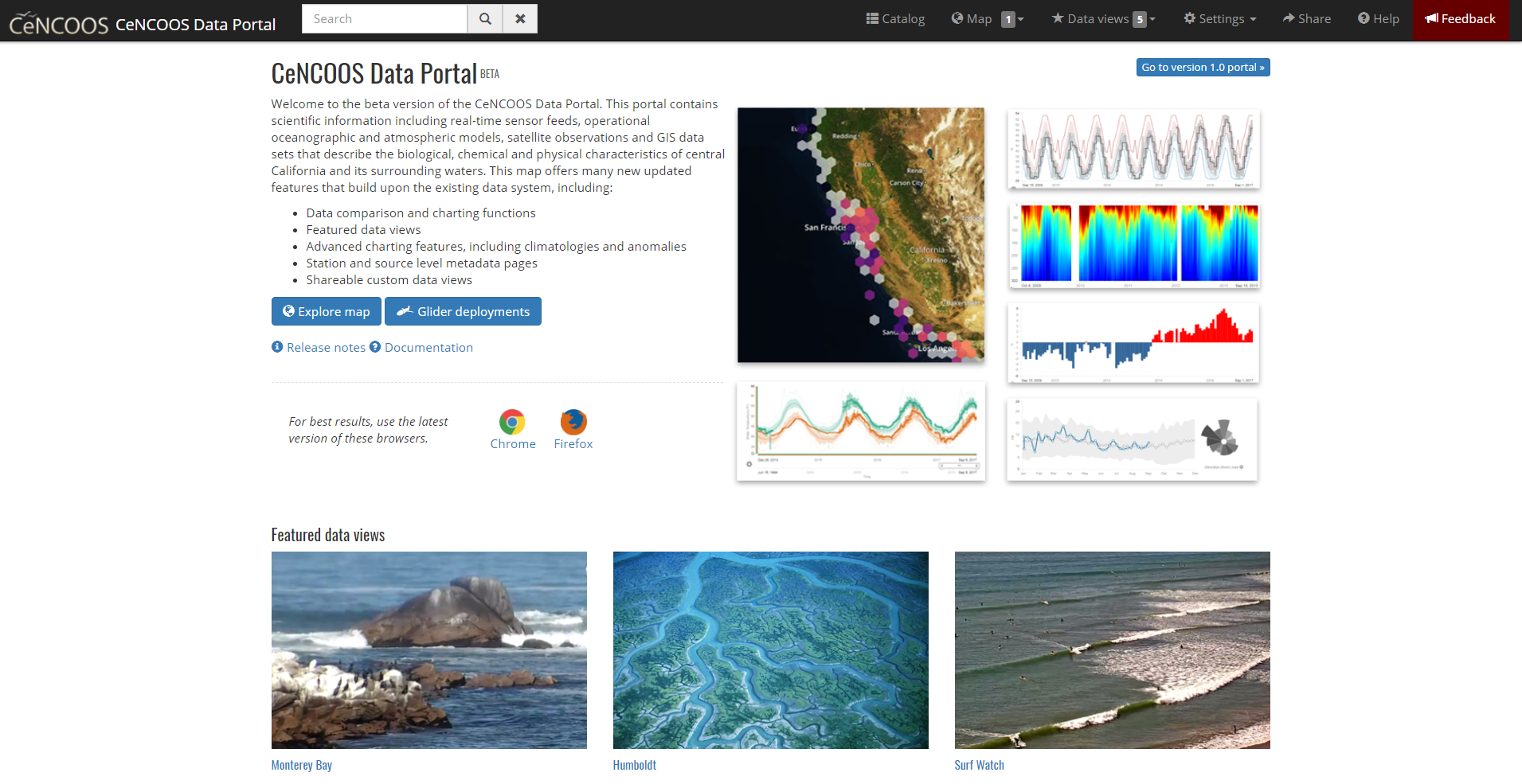
Building on many years of stakeholder feedback, CeNCOOS and its technical partner, Axiom Data Science, have been working on a significant overhaul to the CeNCOOS Data Portal . The updated map gives users access to new features as well as a revamped design to get more out of the CeNCOOS real-time data services. With this latest release, the map has migrated to a new framework that is more responsive and adaptable to long time series from stations, as well as being updated with more advanced discovery and sharing capabilities. The map offers sophisticated charting abilities, including comparisons between data sources, binning by time, and plotting of climatologies and anomalies. Additionally, ocean profiling sensors have been updated to show depth charts, interpolation via kriging, and 4D interactive charts. This new portal also features Data Views which are user-created compilations of sensor outputs to spotlight environmental events or geographic locations. Users can create make own data views using real-time, biological, or other environmental data to explore trends and to store or save those views with others.
May 21, 2018
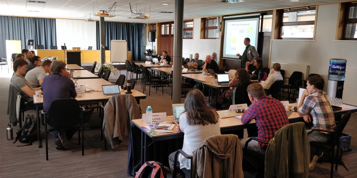
This year’s IOOS Data Management and Communications (DMAC) Meeting took place from May 21-23 at the Silver Spring Civic Center in Silver Spring, Maryland. The meeting was a chance for data managers from all of the different IOOS Regional Associations and other groups to get together and discuss a wide range of topics from data quality control to web analytics. Here Axiom’s Rob Bochenek, Kyle Wilcox, Stacey Buckelew, and Jessica Austin presented on several topics, including the IOOS Environmental Sensor Map , the MBON data portal , the IOOS Animal Telemetry Network’s Data Assembly Center (DAC) , the SECOORA WebCat- Live Cameras and Historic Feeds , and more! The meeting was a great opportunity to share experience and demonstrate new technologies with other data managers and helps foster the already strong IOOS-DMAC community. Visit here for more information about this and past meetings.
 </a>
</a>
May 3, 2018
The Marine Biodiversity Observation Network (MBON) is composed of regional networks of scientists, resource managers, and end-users working to integrate data from existing long-term programs to improve our understanding of changes and connections between marine biodiversity and ecosystem functions. MBON sponsors and partners met at an all-hands meeting on April 27, 2018 in Washington, D.C.
Brian Stone (Axiom) presented new portal functionality including data views featuring MBON biological indices compared with time-series of environmental data. Axiom has been working with these data in the MBON regions of Florida, California, and Alaska.
April 29, 2018
Axiom participated in the 2018 North by North Festival hosted by Institute of the North at the Anchorage Museum. The festival featured presentations and panel discussions with people from 15 countries including the US, Canada, Finland, Norway, Iceland, Greenland, Scotland, Germany, and more. Topics were wide ranging, from art and film to smart cities and interconnectivity, to food and health in northern latititudes.
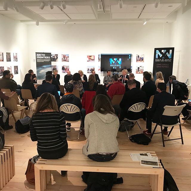
In a session on Climate Action on Friday, April 27th, Axiom’s Will Koeppen presented on Arctic climate data accessibility, making the case that, “Whether it’s policy, recreation, or design, we need to know that the decisions we’re making are based on real information.” He showed recent tool advances (developed in part for Alaska Ocean Observing System data), such as anomaly plots for the city of Nome, and new graphing techniques for long-term climate series such as sea ice off the coast of Utqiaġvik. Other presenters in the session talked about recommendations for protecting rural communities from climate change (Max Neal, ANTHC), how black carbon is affecting glaciers in Canada, and the use of algae in carbon capture (Nathan Morrison, Sustainable Now Technologies).
On Saturday, April 28th, Will, Ronni Wilcock (Two Bears Environmental Consulting), Erica Betts (PDC Engineers), Laura Young (AECOM), Judy Chapman (State of Alaska DOT) participated in a panel discussion moderated by Erin Trochim (Alaska Climate Adaptation Science Center, UAF) in the East Gallery of the Museum. The panel was a fishbowl conversation centering on Climate Action - Community Risk Data and Response Options. Approximately 15 other attendants from the conference joined the panel in an open conversation. One of the most interesting topics was brought up by Malinda Chase (AK CASC) related to “data sovereignty”, especially in relation to collecting data from rural Arctic villages. Other questions revolved around duplication of effort when data is not shared, data repositories for emergency response, privacy issues, and how researchers collecting data should be working to take data back to communities where it’s collected (e.g., in the form of maps).
April 28, 2018
Between 23-26 April 2018, Axiom’s Kyle Wilcox joined 21 participants from 8 countries representing the major animal telemetry networks in Africa, Australia, Canada, Europe and the USA met at the IOC project office for IODE in Ostend, Belgium to test the OBIS-ENV-DATA standard through the development of data products for scientific applications.
The participants agreed to use the OBIS-ENV-DATA DarwinCore standard to exchange and publish detection data through OBIS (both acoustic and satellite) and work with OBIS and the scientific community to develop data products for the Essential Ocean Variables (EOV) of the Global Ocean Observing System (GOOS), in particular the “Marine turtles, birds, mammals abundance and distribution EOV” and the “Fish abundance and distribution EOV”.
The guidelines for the implementation of the OBIS-ENV-DATA standard for tracking data (acoustic and satellite detections) will be further finalized and documented in collaboration with the data standardization working group of the International Bio-logging Society.
In collaboration with several scientists involved in animal tracking, the OBIS secretariat is developing a data aggregation tool (which will be available as an R package) to calculate home ranges, migration pathways and movement patterns based on the tracking data in OBIS. It is expected that new public tracking data will be made available to OBIS before mid 2018 and the first products be available early 2019. It was felt important that OBIS provides access to the relevant (aggregated) data used to calculate the scientific products and provide links back to the original (raw) data sources to ensure proper data provenance and allow reproducibility.
This was the first workshop of the IODE pilot project OBIS-Event-Data, which aims at seeking early adopters of the OBIS-ENV-DATA standard and develop data products and scientific applications in particular to support the work of the Biological and Ecosystem EOVs of GOOS and the Marine Biodiversity Observation Network of the Group on Earth Observations (GEOBON MBON).
Learn more at the OBIS website.
March 16, 2018
Building on many years of stakeholder feedback, Axiom Data Science together with the South East Coastal and Ocean Observing System (SECOORA) have been working on a signifcant overhaul to the SECOORA Data Portal. These updates were presented to SECOORA stakeholders by Axiom’s Stacey Buckelew and Brian Stone udring a Feburary 27 webinar. The updated portal is currently available in beta version (v2.6) to give users access to new features and a revamped design to get more out of the SECOORA data services. The new portal exists on a platform that is more responsive to long time series observations, and has been updated with more advanced discovery and sharing capabilities. The portal offers sophisticated charting abilities, including comparisons between data sources, binning by time, and plotting of climatologies and anomalies. Users can create custom compilations of sensor and model outputs, which can be shared to spotlight environmental events or geographic locations. Ocean profling sensors, such as gliders, have been enhanced to display depth charts, interpolation via kriging, and 4D interactive charts.
Feedback from test users on the new interface will be integrated into the final, operational version that is expected to replace the current one in April 2018. With these new features, the SECOORA Data Portal will serve as a more powerful tool for users to explore relationships and trends in the physical, chemical, and biological data collected from the waters surrounding the southeast coastal region.
To check out a demonstration of the new portal capabilities, the webinar can be watched HERE. Or, visit the v2.6 beta version of the SECOORA data portal.
February 16, 2018
Axiom Data Science recently presented their work on using big-data techniques to analyze AIS vessel traffic data at the 2018 Ocean Sciences Meeting in Portland, OR.
The Automatic Identification System (AIS) is a system of shipboard transmitters and land-based and satellite-based receivers that allow vessel locations to be broadcast and recorded. While traditionally used for real-time maritime applications, there is increasing interest in using these rich datasets to provide insight into a wide array of oceanographic problems, such as prioritizing hydrographic surveys, predicting the probability and impact of oil spills, quantifying the amount of vessel interactions with marine wildlife, and more.
Due to immense size of these datasets—typically 10s of billions of raw messages per year—and limitations on infrastructure and computing power, AIS data must currently be processed in small temporal or spatial subsets. This has proven inadequate for decision-making that requires analysis on a national or global scale over an entire year. To overcome the limitations of traditional data storage and processing infrastructure, we have developed a big-data compute cluster using Apache Spark as the computing engine.
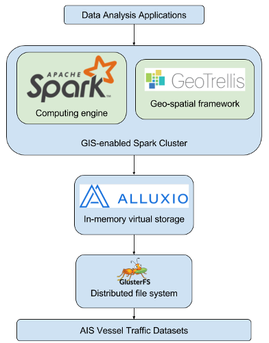
As a demonstration of this technical approach, we worked with NOAA’s Office of Coastal Surveys to produce vessel traffic heatmaps for use in their Hydrographic Health Model. Starting with a 2015 terrestrial AIS dataset composed of 74 billion raw messages, we used our computing cluster to parse the messages, clean out invalid data, and aggregate the individual messages into 20 million tracklines, representing distinct ship voyages per day. We then used these voyages to produce a set of heatmaps in GeoTIFF format with 500 meter resolution across two different metrics: total traffic volume and unique vessel count. We also developed the ability to run ad-hoc queries against both the raw messages and ship voyages.
The previous state-of-the art, an ArcMap plugin, takes days to weeks to process raw AIS data for one month in one UTM zone. In comparison, processing time for this analysis, which included all US waters for all of 2015, was only 48 hours using our computing cluster.
We’ve since analyzed almost ten years of AIS data across all US waters, and will be focusing on arctic AIS data from the Marine Exchange of Alaska in the upcoming year.
For more information, see the following resources:
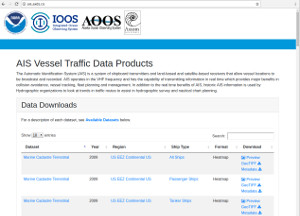
Download the datasets and learn more about the analysis at the publically-available AIS Vessel Traffic Data Products website.
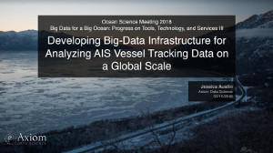
Download slides for the OSM 2018 presentation, Developing Big-Data Infrastructure for Analyzing AIS Vessel Tracking Data on a Global Scale.
Watch a video that goes into more depth about the project's background.
February 16, 2018
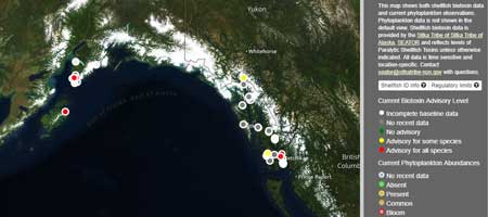
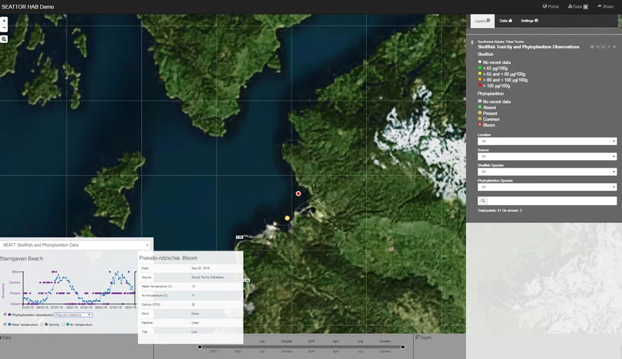
Axiom Data Science has been working with a group of scientists to share information related to harmful algal blooms in Alaska.
Under the umbrella of the Alaska Ocean Observation System, part of the national Integrated Ocean Observation System (IOOS) network, a partnership of state agencies, Alaska Native organizations and the University of Alaska has launched the Alaska Harmful Algal Bloom Network. The intent is to stitch together a statewide approach to researching, monitoring, responding to and spreading information about harmful algal blooms in the state.
Axiom has been supporting the group through the development of the AHAB portal, which displays shellfish and phytoplankton data at monitoring locations throughout Southeast and Southcentral Alaska. To access the portal click here.
The Alaska HAB network was featured in recent news articles by NOAA, the Peninsula Clarion, the Homer News, and the Kodiak Daily Miner.
February 8, 2018
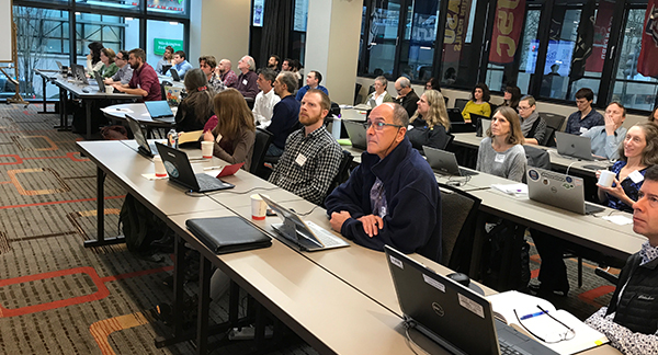
The inaugural Integrated Ocean Observing System (IOOS) Biological Data Training Workshop was held February 8-9, 2018 in Seattle, WA. The workshop built on the successful partnership between IOOS and the Ocean Biogeographic Information System (OBIS) to develop a community of practice around the management and analysis of biological ocean observing data. It provided hands-on training to partners from the IOOS Regional Associations, Marine Biodiversity Observation Network (MBON), National Centers for Environmental Information (NCEI), Federal and State government agencies, Smithsonian MarineGEO, Ocean Tracking Network, Animal Telemetry Network, Ocean Networks Canada, and Fisheries and Oceans Canada. The objective of the workshop was to educate participants in the benefits, goals, technology and process to make biological data more widely accessible in standardized formats and disseminated via community systems.
The workshop began with an introduction to applications of biological data, including the MBON Portal (presented by Axiom’s Brian Stone, Luc Mehl, and Stacey Buckelew), OBIS Portal, MBON Explorer and Infographics, and MBON Seascapes. Participants were then introduced to IOOS and OBIS standards and tools for biological data and web services for data access, like rOBIS and ERDDAP. Following these presentations were several hands-on sessions where participants could begin to align their own data to the Darwin Core standards, WoRMS taxonomy, and metadata standards that are used for reporting on global biological diversity data.
Follow these links to visit the MBON Data Portal (v2.0) or read the full article.
“This workshop is an important first step towards greater collaboration in making marine biological data available on an international scale. As the community of practice continues to develop we will see significant developments in our ability to understand our oceans.” – Kevin Gallagher, USGS Associate Director for Core Science Systems
Workshop participants at the first IOOS Biological Data Training Workshop. Photo Credit: NOAA/IOOS
January 11, 2018
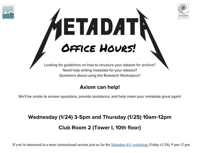
Axiom Data Science will be holding a metadata workshop (Metadata 411 on Friday morning, 9am - 12pm) and hosting 2 metadata office hours sessions (Wednesday at 3pm and Thursday at 10am) at the Alaska Marine Science Symposium later this month. If you’ve got questions about how to organize and/or document your dataset, the office hours would be a great time to drop in and talk with us about it. If you’re interested in learning more about metadata in general, the Friday workshop will be a hands-on walk through of how to write high-quality metadata using the Research Workspace’s built-in editor. We hope to see you there!
November 16, 2017
 We are pleased to announce the addition of a new Metadata Technician to the Axiom team—welcome aboard, Melany Wilson! Melany has worked as a Science Technician on various research projects in Alaska and Antarctica. She has a Master of Science in Environmental Science with a focus on Geographic Information Systems from Alaska Pacific University. She worked at the University of Wisconsin-Madison as a Senior Instrumentation Technician at the South Pole Station building a high energy neutrino detector called the IceCube Neutrino Observatory. Originally from North Carolina, she has lived in Alaska for nearly 20 years. She loves to ski and climb mountains.
October 24, 2017
![]()
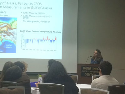
This month, Axiom participated in the kick-off meeting for the new Northern Gulf of Alaska LTER site. The Long Term Ecological Research (LTER) program is an NSF-funded network of 28 sites with long and rich histories of sustained data-collection. The NGA LTER site will build upon decades of oceanographic sampling along the Seward Line transect and the Gulf of Alaska mooring (GAK1), while expanding the sampling routine performed at each station and introducing new several new transects. The new Northern Gulf of Alaska (NGA) site is one of three new sites selected in 2017 for LTER support, along with the North East U.S. Shelf and Beaufort Lagoon Ecosystem sites.
Axiom’s role in the NGA LTER will be as LTER site information managers. We’ll be responsible for helping NGA LTER scientists understand and meet data management requirements. We’ll use the Research Workspace for sharing and managing data and for writing metadata, and we’ll use the integrated Jupyter notebooks for visualizing timeseries, anomalies, and modeling results.
October 18, 2017
The Cook Inlet Response Tool is designed to help oil spill responders understand important environmental factors and resources in the area surrounding an oil spill, such as commercial fisheries, nearby marine mammals and wildlife.
The Cook Inlet Regional Citizens’ Advisory Council helped build the tool with the Alaska Ocean Observing System and Axiom Data Science. Within the next year, the tool will be expanded to include data on important subsistence and personal use resources. These data are important for managers and oil spill responders to understand which areas are being used by local residents to harvest wild resources.
The full article from KBBI media can be accessed here.

Cover photo courtesy of Davin Holen. A family fishes near Tyonek.
October 11, 2017
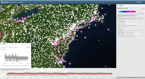
Building on many years of stakeholder feedback, we have been working on a significant overhaul to the shared infrastructure for our partners data portals, including the Integrated Ocean Observing System (IOOS)’s Environmental Sensor Map, the Alaska Ocean Observing System (AOOS)’s Ocean Data Explorer, the Southeast Coastal Ocean Observing Regional Association (SECOORA) Data Portal, the Central and Northern California Ocean Observing System (CeNCOOS) Data Portal, and more. The updated portal gives users access to new features as well as a revamped design allowing for more data services. With this latest release, the map has migrated to a new framework that is more responsive and tailored to viewing long time series from stations, as well as being updated with more advanced discovery and sharing capabilities. The map offers sophisticated charting abilities, including comparisons between data sources, binning by time, and plotting of climatologies and anomalies. A new feature, data scenarios, show user-created compilations of sensor outputs to spotlight environmental events or geographic locations. In a later version, ocean profiling sensors will show depth charts, interpolation via kriging, and 4D interactive charts.
Users may now opt-in to the beta version (v2.3) when visiting the landing pages for these portals, where the old version will still be available. Incremental changes will be made to the beta version through March 2018, each with additional updates and portal enhancements. Feedback on the new interface and features will be integrated into the final, operational version. With these new features, we are hoping to deliver a more powerful tool for users to explore relationships and trends among data assets within these regions.
To check out the latest version visit:
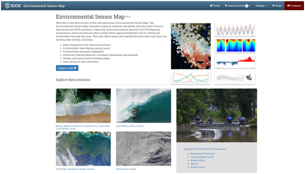
A screenshot of the landing page to the new, beta Environmental Sensor Map. Users can explore data through the map or explore spotlighted data ‘scenarios’.
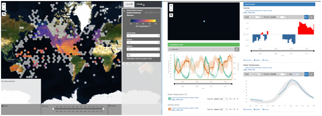
New map interface with palette control (left), and comparison charts between different sensors and parameters (right). Data charts offer user selection of climatology or anomaly views for longer timeseries (>3 years).
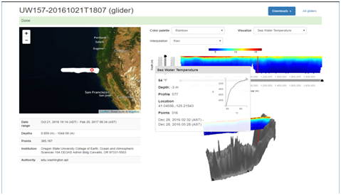
Station level page displaying profile data, including: depth plots, interpolation using kriging, and 4D charting.
September 25, 2017
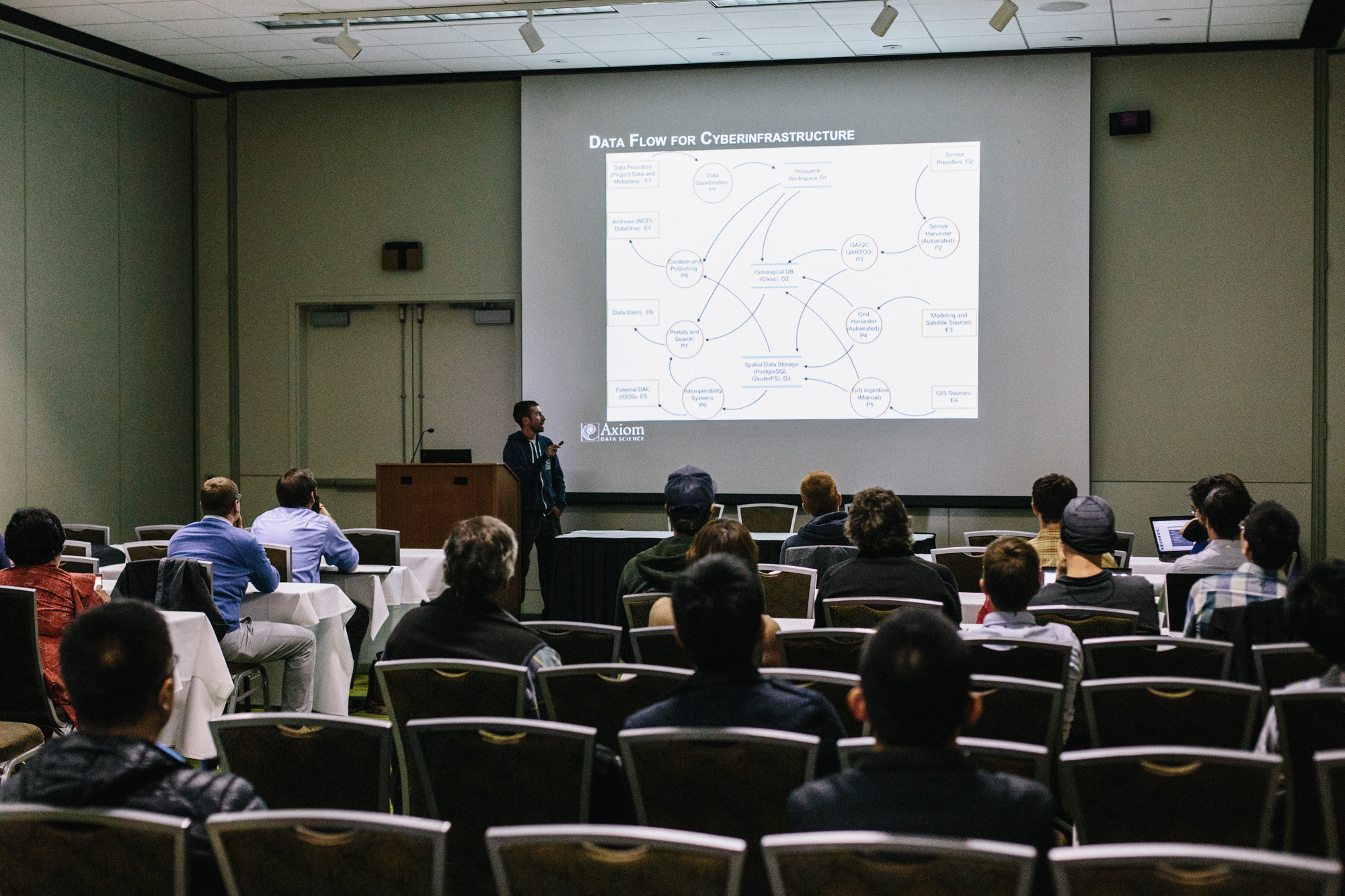
This past week Axiom was pleased to have the OCEANS17 conference at our front door in Anchorage, Alaska. Twice each year, the Marine Technology Society and the IEEE Oceanic Engineering Society sponsor OCEANS, a prestigious conference/exhibition that draws an international audience of more than 2,000 attendees. Axiom participated in the conference by hosting a half-day workshop, Data Management in the Ocean Sciences: Technologies, Tools, and Approaches Learned From a Decade Managing Data. The entire Axiom team was present en masse to provide a view into the new technologies we’ve implemented to help agency and industry partners meet their data management challenges. From high-performance compute clusters, cloud-based data sharing in the Research Workspace, data hosting and visualizations, interoperability systems, to minting DOIs, and publishing datasets and metadata in the Research Workspace DataONE member node, we covered our end-to-end approach for stakeholders to manage data throughout its entire lifecycle.
In addition to presenting part of our tutorial, Axiom CEO, Rob Bochenek, co-chaired sessions on “Marine GIS and Data Fusion,” and “Information Management and Visualization,” and presented a paper titled Cyberinfrastructure to Support Data Management that he co-authored with our data librarian, Chris Turner. Their paper will be accessible through the IEEE Xplore Digital Library once the conference proceedings have been published and is available here as a pre-pub.
If you missed out on one of the Axiom t-shirts or hoodies we gave away at our tutorial, you’ll have another chance. Look for us at the 2018 AGU Ocean Sciences Meeting held 11-16 February 2018, in Portland, OR (the backyard to another Axiom office!).
September 22, 2017
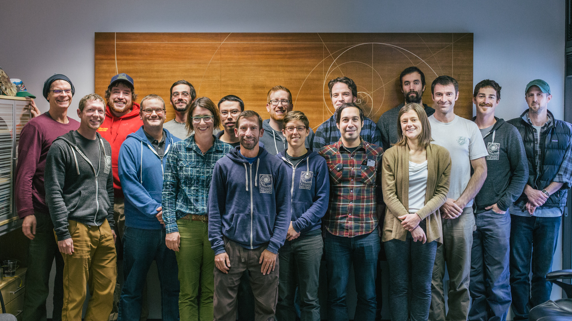
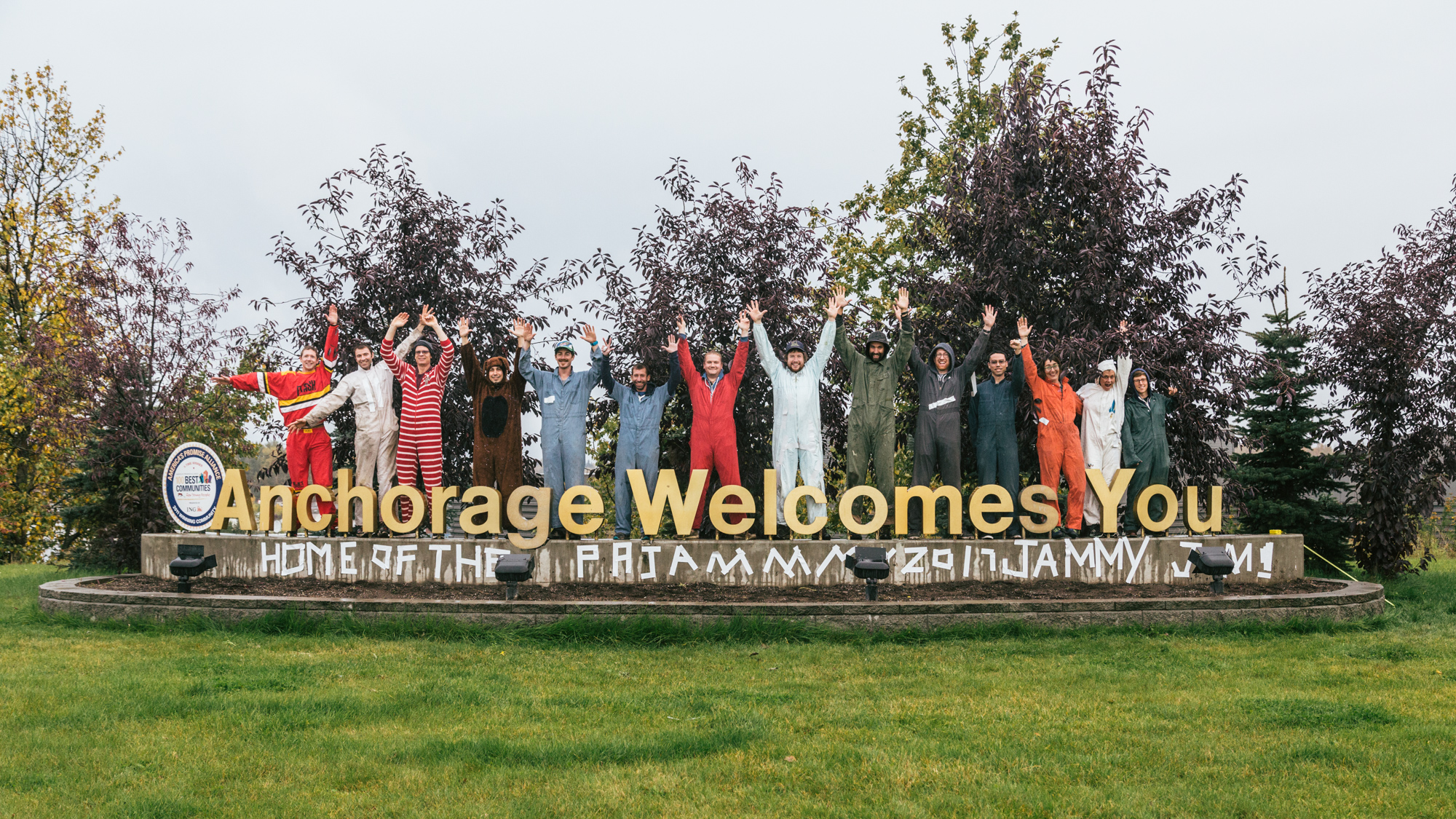
Axiom held its fourth-annual Pajama Jammy Jam (PJJ) staff retreat and strategic planning session in Anchorage, AK from September 18th to 22nd. This week of intense planning, problem solving, and foosball serves as a chance for staff from our offices across the country to come together, get facetime, and develop our vision for the coming year.
This year’s PJJ featured a stirring State of Axiom address from CEO Rob Bochenek and a corporate team-building exercise to beautify an Anchorage community landmark. There was plenty to discuss as Axiom has big plans for the coming year, including the full public launch of the Research Workspace, updated sensor map technology, and lots of opportunities for new data partnerships.
This year’s PJJ was held concurrently with the Oceans17 conference, hosted by the Marine Technology Society and the IEEE Oceanic Engineering Society. Axiom’s contributions to that conference will be detailed in an upcoming blog post. Stay tuned!


September 1, 2017
Axiom and Alaska Ocean Observing System partnered with the Northwest Arctic Borough (NWAB) to recently complete a Digital Atlas for their Subsistence Mapping Project. Subsistence hunters and gatherers in the Arctic are valuable knowledge holders of environmental information in their area. Incorporating their traditional ecological knowledge with other physical, ecological and socioeconomic information can offer planners, managers, and communities a deeper understanding of the Arctic environment and its subsistence resources.
To make important information from the region publicly available, a digital atlas was developed that includes a subsistence map layer, mapped Inupiaq place names, and important ecological areas. The atlas was coupled with instructional videos on how to find, explore, and understand mapped information. If you haven’t already, you can check out the videos made by the NWAB below. Spoiler alert: there might be a surprise cameo by Axiom’s own CEO, Rob Bochenek. Thanks NWAB—keep up the good work. We love ‘em!
August 8, 2017
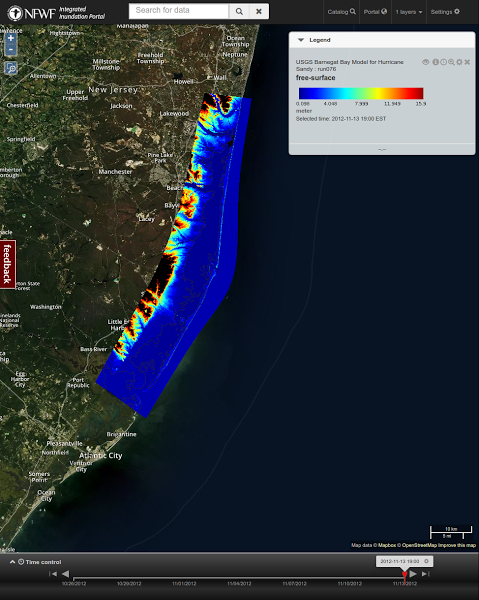
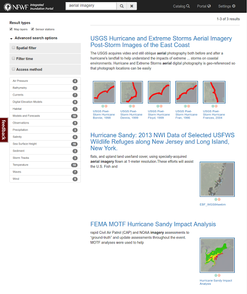
Axiom recently completed work on a collaboration with members of the Gulf of Maine Research Institute, US Geological Service, and the Northeastern Regional Association of Coastal Ocean Observing Systems on a National Fish and Wildlife Foundation project entitled Improving Access and Usability of Storm-Related Data.
Our role in the project was to collect, organize, curate, and document storm-related data over the area of the US affected by Hurricane Sandy. We ingested over 40 datasets and 245 map layers related to or produced as a result of Hurricane Sandy. Many of these datasets were originally only available from the source institution or group and were in a variety of different formats, each requiring different toolsets. Within the Hurricane Sandy Data Integration Portal, they’re available as stand alone or stackable visualized data layers, and they’re hosted through OGC-compliant services and now widely available to the public.
While participating in this porject, we contributed heavily to the ncWMS software package and associated visualization libraries as part of this project. ncWMS is an OGC compliant Web Map Service for geospatial data that are stored in CF-compliant NetCDF files (satellite, in-situ, forecasts, hindcast reanalysis, etc). Our focus was to expand the number and types of data that were supported by ncWMS as well as make it easier for individuals and organizations to stand up their own ncWMS servers and host their own data. We also focused on optimizations and enhancements resulting in a substantial improvement in rendering speed of large datasets and enabling more efficient use of high-performance computing infrastructure. Enhancements to the software libraries included improved portability through Docker containerization, deployment of continuous integration for development, more robust handling of parameter input for queries, implementation of a RESTful API for dataset metadata queries, exposed Ehcache parameterization, implementation of distributed caching using Terracotta and various minor bug fixes. These efforts increased accessibility to datasets and enabled faster access to large datasets including notable improvement for unstructured grid models. For more information on ncWMS see the documentation.
August 3, 2017
![]()
Axiom is pleased to announce it’s latest update! The Research Workspace has joined DataONE as a Member Node, making it easy for Research Workspace users to export and archive their project data to the DataONE Network. DataONE is a preservation-oriented data center that enables universal access to data and also aids researchers in fulfilling their need for data management and in providing secure and permanent access to their data.
For the full news announcement, click here.
June 19, 2017
![]()

We’ve been busy! Last week the Research Workspace Team at Axiom Data Science replaced the Ocean Workspace with our latest technology: the Research Workspace. The Research Workspace offers many new features to improve data management and collaboration across all stages of scientific programs. We are excited to offer this technology to help accelerate the power of data sharing, documentation, and analysis among you and your research collaborators.
Access to the Research Workspace is currently limited to prior members of the Ocean Workspace while we fine-tune your experience. If you’re not a current member, sign up to be alerted when open access begins.
In developing this new version of the Workspace we’ve incorporated feedback acquired from our dedicated Ocean Workspace user community. The Research Workspace would not have been possible without key partners, including the Alaska Ocean Observing System (AOOS), Integrated Ocean Observing System (IOOS), North Pacific Research Board (NPRB), Exxon Valdez Oil Spill Trustee Council’s Gulf Watch Alaska and Herring Research and Monitoring programs, and the Prince William Sound Science Center. We also want to acknowledge our growing community for their usage and commitment to the Workspace over the years. Thank you for your support!
We have worked hard to offer you the Research Workspace and hope you will be pleased with the new platform.
May 26, 2017
The NOPP Excellence in Partnering Award was presented to 58 collaborators of the “National Marine Sanctuaries and Sentinel Sites for a Demonstration Marine Biodiversity Network (MBON)” at the 2017 MBON-All Hands Meeting on May 26th, 2017 in Washington D.C.
As a collaborator in this effort, Axiom Data Science was pleased to be among the recipients. For the full article click here.
April 6, 2017
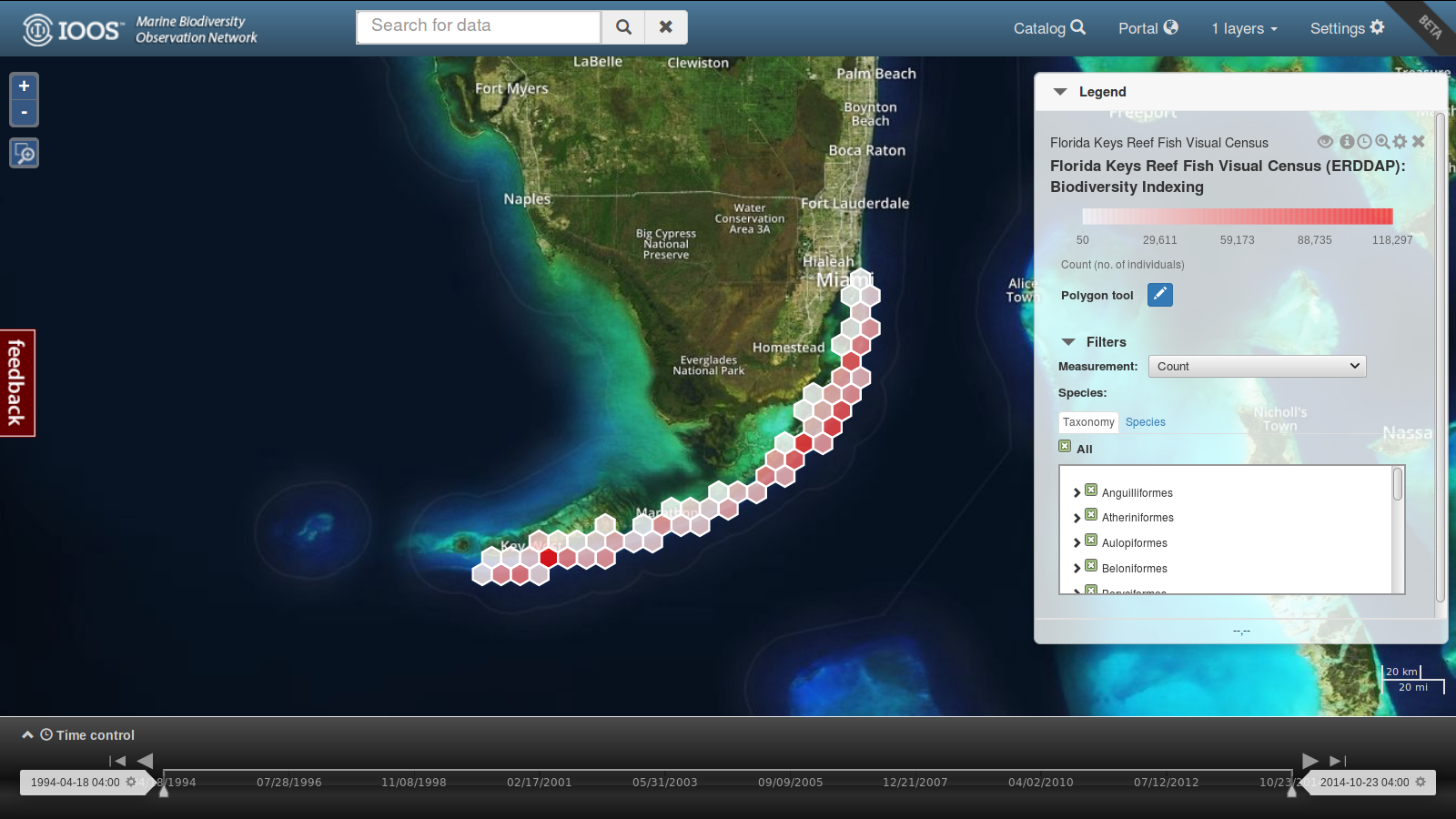
Dr. Ben Best of EcoQuants has posted a short introductory video on using the data portal Axiom built for the Marine Biodiversity Observation Network (MBON).
The MBON portal currently features visualizations of key biodiversity datasets in Alaska, California, and Florida. In the EcoQuants video, Ben highlights the Florida Keys Reef Fish Visual Census ERDDAP data.
Among the many other datasets available to explore, the MBON portal also features fish catch survey data from the North Pacific Anadromous Fish Commission’s Bering Arctic Subarctic Integrated Survey.
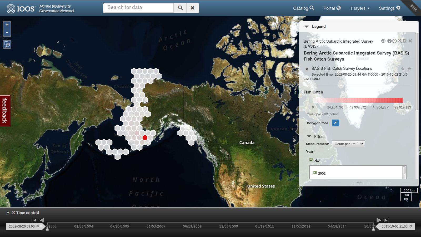
In addition to filtering by time, location, and species—as Ben demonstrates using the ERDDAP data in the video—BASIS data can be filtered by method, life stage, and vessel.
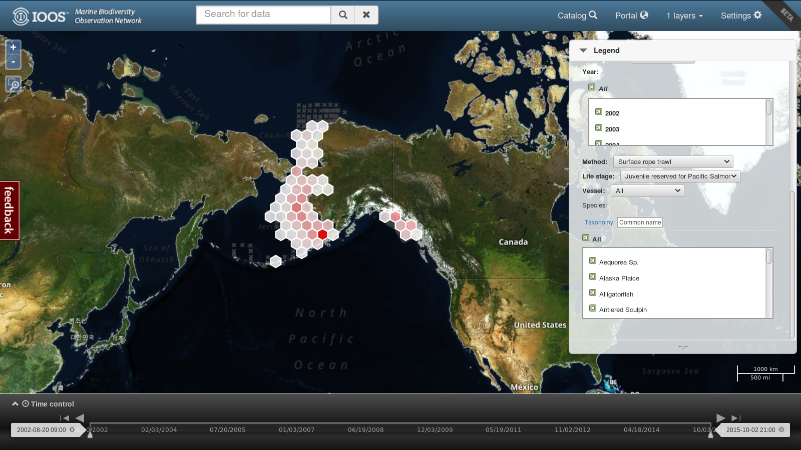
As you can see in the screenshot above, this could allow you to see count data for juvenile Pacific salmon from surface rope trawls from 2002-2015—or any number of other queries.
The MBON portal is still in Beta. More features and datasets will be added in the future. If there is something you’d like to see included please contact info@marinebon.org.
You can access the data portal here.
April 2, 2017
Over the past few months, Axiom has been migrating its physical infrastructure to a new data center in Portland, Oregon. Previously at Atmosera Data Center 3, all of our hardware has now been moved to a larger space in the Pittock Block, a historic Portland building that also contains the Portland Internet Exchange. The move gives us access to more racks (i.e., more hardware expansion room) and faster connections for our High Performance Compute systems.
As we were moving all the hardware anyway, we took the opportunity to upgrade or replace many of our existing blades. This included manually swapping out or installing new CPUs, heat sinks, RAM cards, daughter boards, and infiniband cards; installing the upgraded blades and connecting them to the network to test them, and replacing any defective hardware (when you’re going through a thousand RAM cards, you get to find a few bad ones). As new hardware came online in the Pittock, our software engineers moved over our databases and services, changed IPs to the new locations, and tested them to make sure they all still worked together.


January 23, 2017
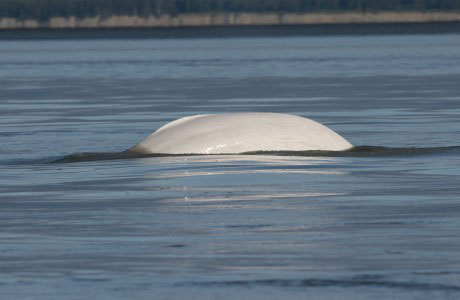
The endangered Beluga population of Cook Inlet has been in the news this past month with the release of a new recovery plan. Axiom Data Science has been continuing work on both the Cook Inlet Beluga Whale Ecosystem Portal, and the Scientific Sightings Mapper, which compiles professional beluga observations from multiple private and public organizations in Cook Inlet. This fall Axiom added thousands of beluga sighting locations to the mapper. Some of these came from our existing partners at the National Marine Mammal Laboratory, LGL Alaska Research Associates Inc. and Joint Base Elmendorf Richardson, but we’re happy to have worked with several new partners:
This Friday afternoon (January 27th) Axiom Data Science CEO Rob Bochenek will discuss this project, and future opportunities for collaboration on Cook Inlet Belugas, at the Alaska Marine Science Symposium workshop on Cook Inlet Beluga Management, Research, and Partnership Opportunities. Come find us there or contact us to work with us on this unique population of whales.
January 11, 2017
Arctic Sea Ice extent is a “hot” topic in Alaska for climate scientists, subsistence hunters, and resource developers. Axiom Data Science and the Alaska Ocean Observing System (AOOS) serve multiple sources of sea ice data:
Shell has withdrawn operations from Alaska, but not before making their full-resolution SIWAC ice maps available to Axiom Data Science. The AOOS Ocean Data Portal is the only access point for SIWAC full-resolution sea ice maps, and now includes maps through October 2015.
January 3, 2017
The end of 2016 marks the end of Axiom Data Science’s 10th year in business. From humble beginnings in Rob’s East Anchorage garage, we’ve grown into an agile, innovative data science company supporting environmental research efforts across North America:
We’re proud of what we’ve been able to accomplish over the past decade. It’s taken a lot of unsung heroics, quick thinking, and good old-fashioned hard work, none of which would’ve been possible without the efforts our dedicated, talented staff and the support of our many data partners.
And we’re just getting started! Looking ahead to 2017, we have a lot on the horizon, including new partnerships, major upgrades to our data center, a suite of more sophisticated data management tools, and the eventual upgrade of our office espresso machine.
Many thanks to everyone who’s been a part of helping Axiom grow and evolve so far. We’re proud to support important research efforts in vital and sensitive areas such as the Gulf of Mexico, the North Pacific, and the Arctic. We’re looking forward to a great next decade and beyond!
December 10, 2016
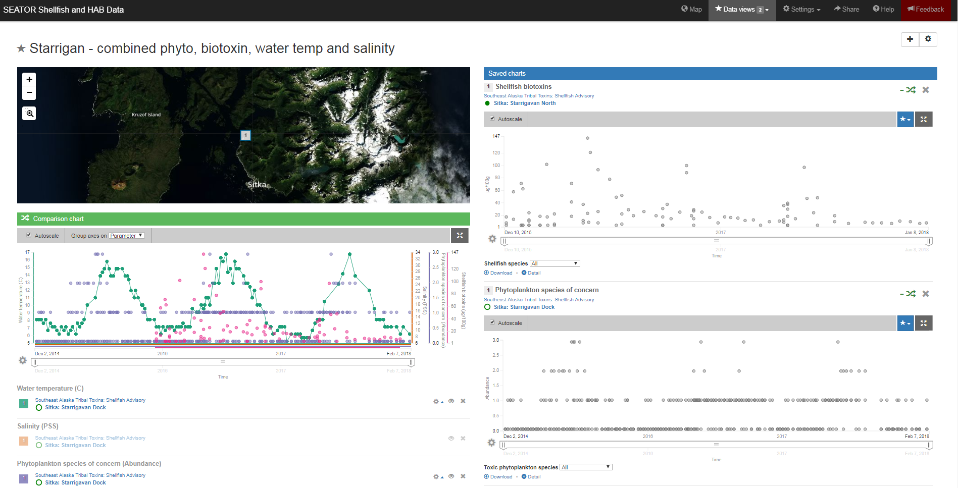
Axiom Data Science and the Alaska Ocean Observing System (AOOS) recently presented at the Alaska Sea Grant’s Harmful Algal Bloom workshop about platforms for phytoplankton and shellfish toxicity data sharing. Here is a presentation synopsis:
Ready access to phytoplankton abundance and shellfish toxicity data is critical to supporting rapid response capabilities for harmful algal blooms (HABs). The Alaska Ocean Observing System (AOOS), in partnership with Axiom Data Science, packages coastal and ocean observation data in meaningful ways to support stakeholder needs. AOOS is in the early stages of developing tools to inform decision-making about the impacts of HABs to humans and the environment in Alaska. Among those available to the Alaska HAB network, the Ocean Workspace is a web-based collaboration tool used to securely centralize scientific data and elect files to be published openly on public data portals. The Ocean Data Explorer and Gulf of Alaska portals provide public access to hundreds of data layers, allowing users to visualize and integrate different types of data from many sources. The Kachemak Bay Harmful Algal Bloom Information System(http://www.aoos.org/k-bay-hab/) includes information on current water temperatures in Kachemak Bay and how these temperatures may affect the development of HABs and resulting shellfish toxicity. Additionally, under development is a data collection and distribution system for phytoplankton and shellfish testing information in Southeast Alaska (via Southeast Alaska Tribal Ocean Research (SEATOR) and SoundToxins.org) that aims to give tribes, researchers, shellfish growers, and managers a data-driven resource for HAB warnings to inform selective harvesting of shellfish to reduce human health risk. This system may provide an important platform for serving the new Alaska HAB network’s statewide need for centralizing data and disseminating it in useful ways to managers and the public.
November 23, 2016
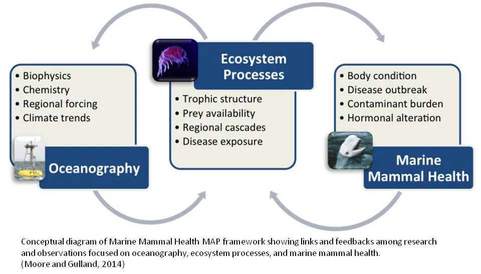
Marine mammals face an increasing number of health threats. The increasing frequency of emerging diseases, harmful algal blooms (HABs), and human interactions suggest a decline in marine mammal health. However, scientific publications about these events are not a reliable indicator of underlying health trends (Simeone et al 2015). Access to centralized, standardized marine mammal health data is important to help highlight and understand the connections between oceanography, ecosystem processes and marine mammal health. The Marine Mammal Commission and the National Oceanic and Atmospheric Administration’s (NOAA’s) National Marine Fisheries Service (NMFS) Office of Protected Resources, in collaboration with Axiom Data Science and other partners, have been developing a nationally centralized, ultimately near-real-time, system for reporting data on marine mammal health called the Marine Mammal Health Monitoring and Analysis Platform (MMHMAP). Beginning in October 2016 a project led by Axiom Data Science is working to develop the user interface, visualization and analysis tools for Health MAP.
More information can be found through the MMHMAP website here.
November 17, 2016
Axiom is pleased to announce the hire of Jesse Lopez, as the Scientific Computing Technologist for the Portland, OR office. In this position, Jesse will serve in an infrastructure engineering and numerical science capacity to contribute to the advancement of Axiom's web-based data management tools. Jesse will also be working to maintain and cultivate Axiom’s high performance computing infrastructure located in Portland. Jesse’s professional interests lie at the intersection of environmental science and computational science. He studied History and Mathematics at the University of Washington (BA), Computational Mathematics at Brooklyn College (Post-Bac), and Environmental Science and Engineering at Oregon Health & Science University (OHSU). His dissertation work at OHSU was focused on developing and applying high-resolution numerical models and observations to study circulation and sediment dynamics in the Columbia River estuary. Jesse also has extensive experience teaching Mathematics and Computer Science from middle school, as a member of AmeriCorps, to upper-level undergraduate courses. Away from his laptop, Jesse enjoys listening to records and drinking tea with his orange cat.
October 25, 2016
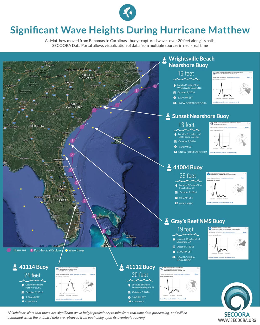
As Matthew moved from the Bahamas to the Carolinas, ocean observing technology – such as buoys - captured waves over 20 feet and wind speed of over 50 knots along its’ path. Buoys, coastal stations, forecast models and other ocean technology transmit data – such as wind speed and wave height – in near real time to data servers and portals. Near real time data is used by weather forecasters and Emergency Response Managers to confirm what the models are predicting and report the true conditions. It helps them accurately decide the best way to respond to dangerous situations.
The Southeast Coastal Ocean Observing System (SECOORA) Data Portal, developed in partnership with Axiom Data Science, allows visualization of data from multiple sources in near real-time. To view the Hurricane Matthew track as measured by wave and ocean buoys, and for the full article click here.
October 25, 2016
In a recent Journal of Marine Science and Engineering publication, co-authors from U.S Geological Survey, Southeast Coastal Ocean Observing Regional Association, and Axiom Data Science describe a workflow that automates the skill assessment of water temperature forecasts from multiple ocean forecast models, allowing improved forecast products to be delivered. These workflows are designed to adapt as new data enter the data system, facilitate reproducible science, provide templates from which new scientific workflows can be developed, and encourage data providers to use standardized services. The full article can be accessed here.
October 24, 2016
AOOS and Axiom Data Science are partnered in two five-year monitoring grants by the Exxon Valdez Oil Spill Trustee Council to provide data management services for long-term research and monitoring in the region of the Gulf of Alaska affected by the 1989 oil spill. These long-term programs are the Herring Research and Monitoring Program and the Long Term Monitoring Program, also known as GulfWatch Alaska.
Axiom, AOOS, and program researchers recently attended the annual meeting held in Cordova, Alaska, which was hosted by the Prince William Sound Science Center. Key findings from the 5-year research and monitoring efforts were shared, with a focus towards ecosystem-level synthesis of scientific results. Time was also spent planning and coordinating the upcoming 5-year activities. The meeting culminated in an outreach event to spill-area community members to encourage their understanding about the state of the marine environment and injured natural resources.
Axiom would like to extend our gratitude to the Prince William Sound Science Center for such a fine welcome to Cordova. We look forward to our next 5 years supporting these programs!
October 5, 2016
Last week the U.S. Integrated Ocean Observing System (IOOS®) held their fall meeting in Anchorage, Alaska, hosted by the Alaska Ocean Observing System. The meetings brought together directors from the IOOS Association, the IOOS Program Office, the 11 IOOS Regional Associations, and various NOAA offices. Discussions were focused on multiple facets of a national ocean data strategy, including future priorities, data gaps, and how to expand ocean observation capabilities. We were excited to participate in the meeting and had the opportunity to host an afternoon session in our office where we demoed some of our latest developments, including national products for the IOOS Program Office, interactive 4D ocean visualizations, and reproducible Jupyter Notebooks in a collaborative, computational workspace. The meeting culminated in an Axiom-IOOS ping pong match on the conference table. We won’t say who won; only that there is more in Axiom’s future than fine-tuning ocean data.
Thanks to the entire IOOS team for visiting us in Alaska. We look forward to many more prosperous years together!
September 16, 2016
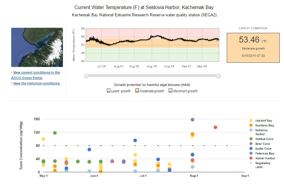
Axiom Data Science, in partnership with the Alaska Ocean Observing System and the NOAA/NCCOS Kasitsna Bay Laboratory, are pleased to announce the release of the new Harmful Algal Bloom Information System for Kachemak Bay.
Harmful algal blooms (HAB) have long been a threat in some coastal Alaskan communities. As ocean temperatures rise over the next few decades, HABs are expected to occur more frequently. While the State of Alaska regularly tests commercial shellfish toxins, recreational and subsistence shellfish are not tested. Access to information about environmental conditions influencing HABs is important for making informed choices about shellfish consumption to reduce the risk of shellfish poisoning.
This Harmful Algal Bloom (HAB) Information System provides information on current water temperatures in Kachemak Bay and how these temperatures may affect the development of HABs and resulting shellfish toxicity. HABs are large increases in the amounts of toxic species of marine algae, also known as phytoplankton, that can cause human illnesses such paralytic shellfish poisoning (PSP). PSP events can cause illness in people, primarily from eating shellfish that filter phytoplankton for food and may concentrate toxins in amounts dangerous to both people and marine mammals.
This HAB Information System provides information to help in making decisions about whether or not to recreationally harvest shellfish. It is NOT a direct measure of current shellfish toxicity. It is ALWAYS recommended to check advisories from the Alaska Departments of Health and Social Services (ADHSS) and Environmental Conservation (ADEC) before harvesting shellfish.
Access the tool HERE.
September 12, 2016
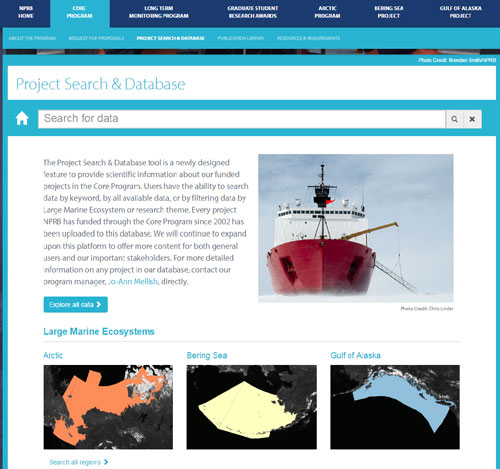
Axiom Data Science has partnered with the North Pacific Research Board to launch a tool that allows access to information from over 638 annual research projects (totalling $71 million in funded research). The Project Search & Database tool is a newly designed feature to provide scientific information about NPRB funded projects in the Core Program. Users have the ability to search data by keyword, by all available data, or by filtering data by Large Marine Ecosystem or research theme. Every project NPRB has funded through the Core Program since 2002 has been uploaded to this database. The tool will continue to be expanded upon in this platform to offer more content for both general users and important stakeholders.
Check out the new tool on the NPRB website here.
August 1, 2016
 Axiom held its third-annual Pajama Jammy Jam staff retreat in Granite Point Mountain Lodge, on Resurrection Bay, outside of Seward, AK. We planned this yearly retreat as an opportunity to unwind and socialize with team members who work remotely in Rhode Island, California, Oregon, and Montana, while discussing our projects and priorities for the coming year. Despite the (almost) non-stop rain, we explored the coastline in kayaks, caught rockfish, leveled up our after-dinner party game skills, and set the agenda for the planning discussions later in the week.
August 1, 2016
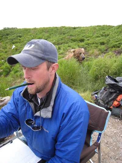 We are pleased to introduce Ian Gill as the new metadata technician at Axiom Data Science. Ian joined the team August 1 to focus initially on metadata services for NPRB annual projects. Ian has over 10 years of field experience and has most recently worked at Alaska Department of Fish and Game as the statewide editor for scientific and technical fisheries reports, where he coordinated reporting standards among dozens of biologists all over the state and curated a report archive that goes back almost 30 years. Additionally, Ian has spent many years working as a field biologist studying bear foraging behavior at the Anan Creek Wildlife Observatory and the McNeil River State Game Sanctuary. With his extensive science editing experience coupled with a research background, we believe Ian will make a strong addition to the Axiom-NPRB data management team. When not in the office, Ian, who is both an accomplished napper and a coffee snob, can usually be found writing haikus, hitting contested three-pointers at the buzzer, or reading Tumble Bumble to his daughter (again). Welcome to Axiom, Ian!
June 6, 2016
We’ve been awarded a contract from the NPRB to provide data management support and services for the Arctic Integrated Ecosystem Research Program (IERP). The Arctic IERP is a multi-component, five year effort designed to study the northern Bering and southern Chukchi Seas to better understand the relationships between physical ocean and environmental drivers (e.g. …) and the structure and function of the biological components of the ecosystem, including human access to subsistence resources. This is a huge effort, with $7.75M in funding from the NPRB, BOEM, and the Collaborative Alaskan Arctic Studies Program (CAASP)1, and an additional $7.25M in in-kind support from other agencies.
The specific data management needs of such a program are many, but all are directed towards the goals of making the data broadly understandable, available, and ensuring it is preserved for future reuse. Our approach is split between data management support and the enhancement of some existing technologies. Data management personnel will provide assistance in creating data management plans; provide guidance and best practices on data formatting and metadata quality; and maintain data and metadata inventories and status reports. Some of the technologies we’ll leverage include:
Look for updates about AIERP data availability and follow program wide progress here.
1 formerly the North Slope Borough/Shell Baseline Studies Program
June 1, 2016
 Axiom helped publicly launch the new IOOS Environmental Sensor Map. This map integrates regional, national, and global real-time data across the IOOS enterprise. Data from observing systems operated by IOOS Regions and local data providers within these regional footprints can be directly accessed through the map. Overall, the map connects to over 31,000 stations providing the latest information on oceanographic and meteorological conditions. There are 71 unique parameters consolidated from over 115 national sensor that report more than 53 million observations weekly! Additional features included in the map are:
May 25, 2016
The Marine Biodiversity Observation Network (MBON) is composed of regional networks of scientists, resource managers, and end-users working to integrate data from existing long-term programs to improve our understanding of changes and connections between marine biodiversity and ecosystem functions. In the United States, MBON projects have been established in the Chukchi Sea (Alaska), Santa Barbara Channel (California), and the National Marine Sanctuaries in Monterey Bay (California) and the Florida Keys (Florida).
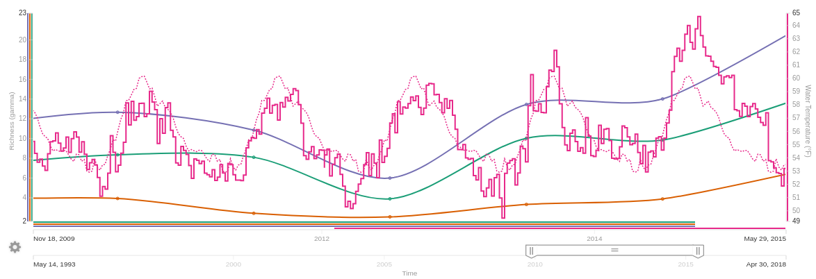
This portal provides real-time, delayed-mode, and historical data for in situ and remotely-sensed physical, chemical and biological observations. Additionally, the portal now features a Biodiversity Index visualization tool on species catch surveys. The available indices vary from simple richness (the number of distinct species), to more computationally advanced Shannon-Wiener diversity and Pielou’s evenness.
Biodiversity can be explored per-sample or per-region, with the regions as either automatically generated hexagons or user-defined polygons. Alpha indices are calculated from the average of the sampling events within the selected area. Gamma indices combine all samples within the selected area and treats them as though they were collected as a single sample. Beta indices are the ratio of gamma/alpha indices. The diversity measurement can also be refined by selecting other filters, including taxonomy. For example, you can visualize the diversity of all samples containing a selected common name, or taxonomic rank, e.g., all samples within the order Perciformes.
Beyond the biodiversity feature, the portal provides visual access to:
Visit the MBON portal to check it out: http://mbon.ioos.us/
May 23, 2016
We are pleased to announce the addition of a new Senior Software Engineer to the Axiom team - welcome aboard Jessica Austin! Jessica has a background in math, physics, mechanical engineering, and control systems from Caltech and Carnegie Mellon where she worked on robotics. She was also a software developer and development/operations engineer at ThoughtWorks and GrubHub. At Axiom, she’s helping us reinvent how our backend systems store, serve, and monitor our big data holdings. This will help harden our software infrastructure to make it more scalable and reliable, and ultimately increase the speed of data access through our clients’ web-based tools.
May 6, 2016
Axiom Data Science, in partnership with the Alaska Ocean Observing System, NOAA, and the Cook Inlet Regional Citizens Advisory Council (CIRCAC), has featured the public release of the Cook Inlet Beluga Whale Ecosystem Portal in the following news articles and radio broadcast:
May 4, 2016
 Government agencies and the public can now find information on the endangered population of Cook Inlet beluga whales on an easy-to-use public data portal through the Alaska Ocean Observing System’s website at AOOS.org. Extensive data on beluga whale sightings and environmental conditions in Cook Inlet has been collected over the past decade, but most of it is not easily found or used by both the public and agency experts. The new Cook Inlet Beluga Whale Ecosystem Portal is intended to correct that by integrating and visualizing beluga whale sighting data with other biological, physical, and socio-economic data in the Cook Inlet region. The portal is freely accessible and aims to improve the management and public awareness of Cook Inlet beluga whales.
AOOS has developed the Cook Inlet Beluga Whale Ecosystem Portal in cooperation with NOAA, the agency that manages beluga whales, the Cook Inlet Regional Citizens Advisory Council (CIRCAC), and Axiom Data Science to provide a tool for ecosystem-based management of the Cook Inlet region. The portal was funded by the National Fish and Wildlife Foundation, with additional support from CIRCAC.
This portal is intended to help with several planning efforts including:
“Having all the pertinent data for managers, the public, local and regional governments, and industry in one accessible location would be of great use to all of us in our future planning and decision-making.” - Port of Anchorage Director Stephen Ribuffo
“A tool that specifically improves access to information related to the endangered Cook Inlet beluga whales will aid in targeting and filling data gaps and will aid in future research and policy decisions.” - CIRCAC Executive Director Michael Munger
“The proposed ecosystem portal will include information not only about the sightings of beluga whales, but will integrate information about natural (e.g., environmental, predator, and prey data) and anthropogenic (e.g., current and proposed development projects) stressors.” - Former NOAA Assistant Regional Administrator for Protected Resources, Jonathan M. Kurland
Photos: https://drive.google.com/open?id=0Bw8AO00ezFjGWElzLU9mWW54NGc https://drive.google.com/open?id=0Bw8AO00ezFjGNDFQd3UyT0pqYUE
April 22, 2016 - Axiom In the News! Rob Bochenek, the CEO and founder of Axiom, was interviewed this April in an evening news feature. To see Rob talk briefly about our history and mission, check out the interview at youralaskalink.com.
Remember, all of the data and maps shown in the video are available in the AOOS Ocean Data Explorer.
April 22, 2016
Rob Bochenek, the CEO and founder of Axiom, was interviewed this April in an evening news feature. To see Rob talk briefly about our history and mission, check out the interview at youralaskalink.com.
Remember, all of the data and maps shown in the video are available in the AOOS Ocean Data Explorer.
March 26, 2016
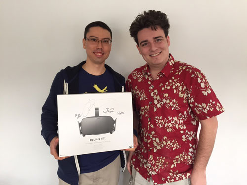 Axiom staff member, Ross Martin, was featured in the news as the first customer of the retail virtual reality headset, the Oculus Rift. Ross received the first publicly-distributed Rift from Palmer Luckey, the founder of Oculus, who delivered the headset in person to the Axiom office while live-streaming the video on Facebook. Congratulations, Ross! Read the full article here.
March 4, 2016
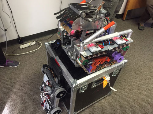 The Fire Island Robotics Team paid a visit to Axiom headquarters in Anchorage, Alaska, to demonstrate their technical expertise and learn about engineering career choices. Axiom staff were very impressed with the robotic teams’ efforts and enjoyed the opportunity to engage with young, bright minds.
January 21, 2016
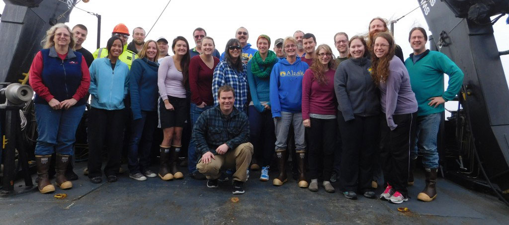
 Axiom Data Science and the Alaska Ocean Observing System (AOOS) are pleased to partner with the new Arctic Marine Biodiversity Observing Network (AMBON) to provide data management support. The goal of AMBON is to demonstrate and build an operational marine biodiversity observing network from microbes to whales. The AMBON field region is located on the Chukchi Sea continental shelf in the US Arctic as a region exposed to climatic changes and anthropogenic influences. AMBON is a 5‐year research partnership (2015‐2020) between university and federal investigators, and integrates with Axiom and AOOS as the central data node to provide a publicly accessible and user‐ friendly database. Through this partnership, AMBON biodiversity data will be made available to a broad audience of users and stakeholders, from local to pan‐Arctic to global. Data management through Axiom/AOOS is an AMBON key component, providing essential compatible linkages to past and present programs and open data accessibility. Data are stored in the Research Workspace and will be made publicly available through the AOOS data portal and archived in national data repositories. Visit the AMBON website for the latest in their Arctic research.
AMBON is funded through the National Ocean Partnership Program, with contributions from the National Oceanographic and Atmospheric Administration (NOAA), the Bureau of Ocean and Energy Management (BOEM), and Shell Exploration and Production Company.